We hiked to Hedges Homestead almost five years ago, starting and ending
at the South Boxley Trailhead (see: 6 Hedges Homestead). Today I’ll be
retracing part of that hike, but this is a different hike altogether, with
extended exploration into Upper Buffalo Wilderness. I’m trying out an ‘alternative’ Hedges
Trailhead parking spot further south. Pulling in off Highway 21 this unmarked road looks more like a driveway and isn’t very long, only about 200 yards.
 |
Low Hole
|
I drive up all the way to the end at the NPS gate assuming there will be
a parking area and room to turn around, nope just a sign on the gate stating, ‘No Parking’. I slowly back out on the
narrow road to the lone driveway where I’m able to turn around. Back towards the highway is a wide spot where
you might squeeze in two small cars,
roomy enough for my truck, I park here. |
Old house at park boundary
|
I hike back up the road and step over the cable gate at the Buffalo
National River boundary and immediately notice an old house on my right. The house in ruin looks pretty inviting but I won’t nose around out of
respect for the private property literally just a few feet away, I keep going west on this old road.
 |
under the powerlines
|
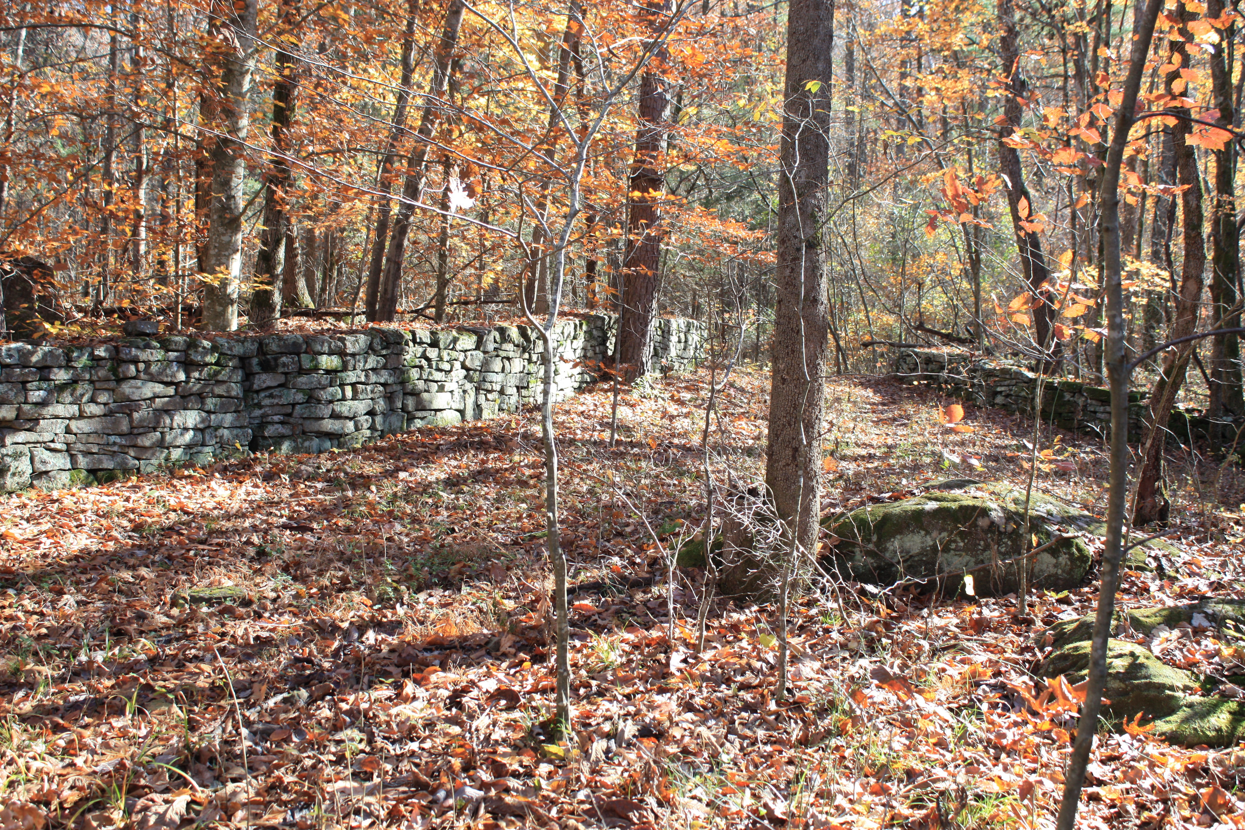
This is easy hiking with very little elevation change, I come alongside
a nice rock wall on my left then another heading north off into the woods
downhill. Soon a road intersection off
to the south up the mountain, this will
need further exploration another day. I
continue west on the main road which is
in surprisingly good shape. But not for
long, I soon pass under the powerlines and the road conditions deteriorate
almost immediately. |
frequent rock walls along old roads
|
For about the next half mile there’s downed trees on the trail one after another, I lost count but at
least four before arrival at the ruins of Whitely Schoolhouse and a few
more after. The Whitely School wasn’t
very big, a one room structure with just the tall stone foundation remaining. A side road circles around behind
the school where I find lots of junk
lying around in the dead leaves, mostly automotive parts.
 |
Whitely School
|
Just past the school is a trail intersection on the right, this is the
main trail north to South Boxley Trailhead, and from here I’m retracing the
route traveled that mild February day almost five years ago. About 300 yards past the school is another
gate, this one marking the wilderness boundary with more downed trees beyond
and an old homesite. |
old homesite stonework
|
This homesite was easy to spot back on that previous visit thanks to the
abundant yellow beds of daffodils blooming all around. Today it’s a little harder to find but the
remains of the television are still here along with at least two outbuildings
possibly a root cellar and maybe a second smaller house. I plug
onward down the road through more deadwood on the trail.
Soon I come into the steep little drainage I’ll call Hidden Valley for the waterfall located
upstream. This creek (although dry today) had little waterfalls everywhere last time we were here. Today it’s just a
very steep boulder field covered in green moss, and 100 feet beyond another
tree on the trail.
 |
one of many 'roadblock obstacles'
|
Passing more rock walls and old trampled fence lines the trail is clear
of fallen timber for almost half a mile to a fork in the road. Here the old road to the right continues down
to Hedges Homestead, but I turn left on a faint old road trace heading mostly
south that sort of just fades away almost immediately. I notice a big rock pile just to the west,
and a good-sized pond behind that,
I’ll call this pretty spot ‘Rockpile Pond’ for obvious reasons. |
this is more like it.
|
I believe any old road is better for hiking than a complete bushwhack.
Sometimes though these old roads seem to just disappear, and you spend a
lot of time and energy trying to reacquire
the road, that will be the reoccurring theme of the day, especially later.
Luckily my map shows this old road
(not always accurately), so I at least have some idea where the road should be. |
Rockpile Pond
|
About a hundred yards after the pond, I find my way back onto the road
which I’ll be able to stay on almost continuously for about half a mile. Along this half mile I step over a rotted big dead tree across the road, the only one I might add, and later a
huge boulder just to the west. Then as
the road begins winding its way down into a little drainage, an old bucket is
hanging from a small tree next to the road. |
a wilderness stream
|
Continuing down I soon cross the dry creek lined with big boulders
everywhere, then a little further downhill a rock cairn next to the faint road
but no sign of a trail or anything significant.
Still heading downhill and approaching the next little creek, a side road heads downhill a little
steeper alongside the creek, I stay on the ‘main’ road soon crossing the
boulder strewn creek, this one with flowing water. |
3-burner gas stove
|
Less than 100 feet after the crossing I notice an obvious trail heading
downhill to the west and decide ‘why not’ knowing if I want to get down to the Buffalo River, I’ll have to leave this old road eventually. The ‘trail’ fizzles out right away leaving me
bushwhacking downhill in a westerly direction, I soon cross another old road as
I continue west. This is pretty clean wide-open woods, I just try to keep heading downhill avoiding steep drop-offs.
 |
home on the river
|
This short bushwhack lasts less than a quarter mile, when I land on
another old road heading downhill to the north and of course a downed tree in
the road right away. Below the road on
my left maybe forty feet down the hill is the Buffalo River, and it looks
deep. Continuing north down the gradual
slope the road soon crosses that same little creek I crossed earlier (up above), and while
making my way through the rocky creek bed I spot a barn up ahead. |
old barn near river
|
Continuing up the creek bank still on the road I see a stone fireplace
to my right, I make my way over to the ‘house’ across the road from the
barn. Not much remains of the house
other than the afore mentioned fireplace and some stone foundation here and
there. An old 3-burner gas stove is
nearby along with sections of the metal flue, and just to the east a stone
lined well.
 |
'sagging' southeast corner
|
Now over to the still standing barn, this impressive log structure has
livestock pens down both sides, an open center with haylofts above. It’s slowly collapsing at the southeast
corner so you should come and see it before a big flood on the Buffalo washes
it away someday. From here I make the
mistake of heading west thinking along the river will be easier hiking, I
should have stuck to the road. |
rocks have 'washed' into the barn
|
Here along the river is a jungle, thick with greenbrier, brush and roses
gone wild. Pinned against all this is
tons of driftwood and other debris, and to make things worse big round rocks
everywhere. No, hiking along the river
is not easier I wind my way east searching for that old road that has got to
be around here somewhere.
 |
near a little spring
|
Eventually I find the road almost against the tall bluff that appears to
have experienced a landslide fairly recently (in geological time). There between the bluffline and the road is a
little spring surrounded by green mossy rocks and making a mud hole of the
road. A little farther the road starts
‘closing in’ on the river, almost a quarter mile past the spring I come to the
river crossing. |
autumn on the Buffalo River
|
The crossing is diagonal 70 or 80 feet over round river rock, but the
water is low I’m able to stay on top the rocks and keep my feet dry, no
footwear changes necessary. On the other
bank where the road emerges is a nice flat rock, perfect for a lunchbreak. I spend maybe half an hour relaxing and
enjoying the soothing sounds of the Buffalo River ‘gurgling’ downstream.
 |
round stone along river
|
Just up the bank is a nice scenic area in open woods with a campsite, and
not far from there Low Hole a very pretty swimming spot on the Buffalo. Low Hole has high banks all around on both
sides of the river, maybe this is why John Moore chose the name ‘Low Hole’. On the opposite bank is a huge flat boulder
jutting out into the river at about the middle of the hole, the flat top is
covered with moss and looks like a great place for sunbathing. |
sunbathers rock at Low Hole
|
I continue north losing then re-finding the road trace a few more times
until maybe a quarter mile later when I cross the Buffalo back to the east side
of the river. This crossing is the same
as before with no footwear change needed.
But I’ve lost the road again, and here the bank is thicker than ever with brush, driftwood and greenbrier.
 |
stonework below Hedge's
|
I scramble away from the river up into the clean open woods but no
sign of the road, oh well this isn’t bad I just keep heading north. A couple places along here have deep cut
banks, apparently the flooding river possibly destroyed part of the road. Eventually I come to a rock wall and old road
now headed east, I know I must be getting close to Hedges Homestead. |
Buffalo River
|
On the road again I soon see some
elaborate stonework above the road on my right, this isn’t the typical rock
wall. Getting a closer look, the stone
and mortar forms a semi-circle just the right height for sitting around a
roaring fire with friends and family.
What do I know, but maybe the Hedges did some outdoor entertaining here.
 |
Hedges Homestead ruins
|
Whatever it is, it’s a short walk up the hill to the opening in the low
wall around the back yard of Harold and Margaret Hedges home. From here I go around the east side of the
house which was burned down about 33 years ago.
I walk up the stone wall lined driveway out to the road next to a small
pond, more info on Hedges Homestead can be found at: 6 Hedges Homestead.
 |
roadside boulder
|
From here it’s almost all uphill back to Whitely Schoolhouse with this
first section the steepest, maybe the steepest climb all day. I soon cross the old cattle-guard which is
barely noticeable through all the dead leaves everywhere. Back at the road intersection where I turned
south earlier the road levels out a little although still going uphill.
 |
backyard at Hedges Homestead
|
The rest of the way back to my parking spot is familiar ground, around
and through many fallen trees passing Whitely School and later under the powerline
before getting back to the truck. It was a little wet and
chilly this morning as I started out but by the time I finished it was quite
nice, sunny and warm.
 |
on Hedges driveway
|
Once again I had a great time in the great outdoors, today I hiked 6.2
miles with 773 feet of elevation change.
This is a wonderful area of the Upper Buffalo Wilderness with many old roads crisscrossing the area not to
mention old homesites galore, I’ll surely need to come back for more outdoor
adventures in the Ozarks.
 |
old home back at trailhead
|
Upper Buffalo Wilderness: Statistics Chart 152 'Hedges Trailhead' parking, (is what I call it) is south of the
entrance to South Boxley Trailhead about 0.9 miles, or north of the entrance
to Smith Creek Nature Preserve about 0.4 miles and looks like a driveway. This is NC 9575 with very limited parking, don’t
block the road. The only reasons to park
here instead of Boxley Trailhead is about 380 feet of elevation gain that isn’t
encountered using this alternate
trailhead/parking.
 |
| base map before fair use alterations is property of USFS--licensed under Creative Commons Attribution-Noncommercial-Share Alike 3.0 U.S. License |


Comments