We were reminiscing the other
day about Richland Creek which seems to get a lot of our attention
compared to other wilderness areas in the Ozarks. It was eleven years ago this past May, the
first time we drove into the area to see some of the ‘roadside’ waterfalls,
namely Falling Water Falls, Intersection Falls and Six Finger Falls. Besides the waterfalls, another enduring memory from that drive down Falling Water Road was the large area
of devastation from the big landslide that took out the road.
 |
2008 landslide area
|
Landslides seem to happen frequently in the Ozarks, this one was
significant since it wiped-out the road.
I learn online, the slide happened in 2008 four years
later the road was finally re-opened, not long before our May 2012 visit as heavy equipment was still
on-site. Today I plan to hike a short segment of the Ozark Highlands Trail
that will take me above the landslide area.
I choose Richland Campground as a parking place, a few other
options are available but just inside the campground entrance is a large flat
parking area that’s close to the signed OHT trailhead at the side of the road
just below the campground.
 |
jagged bluffs above trail
|
I head up the road bank and into the woods, the trail climbs gradually at first getting steeper as I go, easy going so far. There are lots of dead leaves blanketing the forest floor, but Ozark Highlands Trail is
obvious through the leaves thanks to the many white blazes nailed on trees and the
occasional log across the trail with a section cut out for the trail to pass
through.
 |
pointing up to the sky
|
Heading upstream along the rocky little creek (dry today) that I visited
back in February (see:140 Falling Water Road), the OHT climbs some more and turns to the west
away from the creek. After the trail
levels out, I pass near the little campsite I parked at on that short bushwhack
to Rick Henry Falls, now with mostly flat
hiking conditions I often spot the road running fairly parallel to the
trail forty or fifty feet below.
 |
bluffline
|
About a quarter mile later I notice a good-sized rock pointing up to the
sky down the hill a little way, here the trail starts heading uphill again. Now closer to the jagged broken bluffline I
see what could be a couple small caves.
The trail swings more to the south up into a small rocky drainage and
the point where the new landslide
bypass trail section begins.
 |
first vista
|
Where the bypass trail leaves the old OHT is a small sign pointing
the way up the steep rocky drainage with many white blazes along the way as
the trail zigzags up the steep slope.
This is slow going and rough for about 100 feet then the trail leaves
the drainage turning back to the southwest.
Soon leveling out again I pass mile marker 142 and another 200 yards
arrive at a great vista with 270° views.
 |
above the landslide
|
There are many more great views in the next quarter mile of trail which
turns east here and heads uphill even higher before leveling out and arriving
at what I’ll call High Point Rock. A large flat rock perfect for a much-needed break, and incidentally at the highest elevation along this section of the
OHT. I rest here and take a few
pictures, but not for long, with the stiff breeze I quickly get a chill and
decide to move on.
 |
rock garden
|
Now gradually heading downhill the trail slowly curls around to the
east, there are many nice rock formations in the rugged bluffline just uphill and
two or three great vista rock outcrops below the trail to my right. Then the trail drops down and crosses the
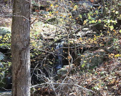
small creek that contains Landslide Falls just under 200 yards downstream. Across the creek I’m once again heading
southwest and keeping pretty level for maybe a quarter mile.
 |
tree on rock
|
As the OHT starts getting a little steep I notice an old road off the
trail on my left, soon the way ahead gets even steeper and rough. The very narrow trail zigzags down through
loose shale, dropping about 100 feet before re-joining
the original OHT, thus ending the
landslide by-pass. Overall the by-pass
trail isn’t the best, at the beginning and end it’s very steep and a little
dangerous, in between isn’t bad and there are some great views so give it a try
but go slow and be careful.
Here the OHT levels out some and circles back towards the southeast as I
enter the little drainage that contains Lilly Falls. From the crossing the trail turns due south
and in a little over a hundred yards is the next little creek, this one
containing Hidden Falls. But I don’t
cross here, instead I leave the trail and head downstream
toward Falling Water Road. Off trail
this is definitely bushwhacking but I’d call it a pretty easy bushwhack since
it's all downhill.
 |
'little falls'
|
When I started hiking this morning at Richland Campground my intention
was to hike into ‘Hidden Hollow’ before turning around and coming back the same
route, that would have been just over six miles. By returning on the road, I cut off about half
a mile and avoided the dreaded steep
parts of the landslide by-pass. Someday
I’ll have to try staying on the original trail (bypass the by-pass) and see if
it’s even possible.
 |
near road in 'Hidden Hollow'
|
The loop I hiked today starting on the Ozark Highlands Trail for three
miles then about 200 yards off-trail down to the road, and finally almost two
and a half miles back on Falling Water Road to the campground totaled 5.5 miles
with 872 feet of elevation change.
Although parts of the trail were rough and the walk on the road a
little mundane, overall I had a great
time in the great outdoors. For a map of today's hike see: (151 Falling Water Creek to Hidden Hollow). |
FR 1205 below OHT
|
Richland Campground Trailhead: Statistics Chart 151 Richland Creek Wilderness can be accessed from all directions, there's too many to give all the possible routes, which you choose largely depends on where you're coming from. Today I came in from the north, first I drove SR 74 out of Mount Judea to Bass which is where the pavement ends. At the south end of Bass where a new bridge is going in, cross Cave Creek on NC 5070 (some maps call this road Cave Creek Rd. on others it's Bass Rd.).
 |
relocated OHT
|
Stay on NC 5070 up the mountain to the 3-way intersection near the northwest corner of Richland Creek Wilderness. Here veer to the left on NC 5080, stay on NC 5080 passing Iceledo Gap then Dickey Junction. You'll cross the county line where the road changes names to Searcy County 1, better known as Forest Road 1205 or Falling Water Road. Continue south to the campground entrance right after crossing Richland Creek on the concrete bridge. From where the pavement ends in Bass to Richland Creek Campground is about 14 miles.


Comments