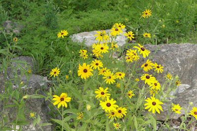
Here it is the end of May, and I haven’t done any hiking since the tenth,
(see: 174 Fern Falls) it has just
been too hot. Today I’m going to nearby
Drury-Mincy Conservation Area, it only takes about half an hour to get
there. By keeping the destination close
to home, I can hopefully get in a
quick hike before the heat of the day.
 |
late spring wildflowers
|
Paved roads all the way to Gunnison Trailhead, I’m on the trail by 8:30
and its 74°, not bad. The Bear Cave
Trail heads west from here, when I hiked that trail (see:112 Bear Mountain Loop) I noticed another trail across
Gunnison Road going east. This is the
trail I’ll explore today, it’s clearly marked at the side of the road, I head
into the woods slightly downhill and curving around from east to north. |
roadside trail sign
|
Although I don’t know for sure where this trail will take me (not yet
anyway), it’s heading in the direction of the Mincy campground area. The trail's in good shape, easy to follow and
well blazed with little ‘hiker signs’
screwed to trees, soon just off the trail is a big old oak that fell down long
ago but remains alive and well. Beyond
the fallen oak the trail drops into the top of Wolf Hollow. |
fallen oak
|
A zig-zagging descent of about 160 feet ends at the creek flowing over
bedrock, here at the very lush overgrown creek a tree has fallen making forward progress difficult. There I notice a faint old road going east up a
gentle hill, thinking this may be the trail I follow the road. But with no more blazes on the trees, I start to wonder if this really is ‘the trail’. |
| 'little hiker' blaze |
My doubts are confirmed at the top of the hill where I come to a tall gate
and fence with a private property sign, going north along the fence a short way
I circle around to the old road and back down the hill. Finding a way through the jungle and across the creek then further
north I make it back to the actual
trail. From here the elevation stays
pretty consistent, soon I see red signs left of the trail warning of the
archery area on the hill north. |
| jungle at Wolf Hollow |
 |
beware of Archery Range
|
The trail goes east along the south edge of the archery range for about
a hundred yards then under powerlines and finally back to the north where this
trail ends at the campground (as I suspected).
The campground may be called ‘primitive’ but it’s pretty nice, with
large open sites some with picnic tables and fire-rings. There is also a parking area and vault toilet,
and of course the entrance to the afore mentioned archery range. |
primitive campground
|
A short access road from the campground leads out to Gunnison Road, I
could walk down the road back to the trailhead, but that doesn’t sound like
much fun. Instead, I go back on the
trail, basically the way I came. Not
exactly the same route, I follow beneath the powerline down to the corner of
the archery area. Then at the top of
Wolf Hollow I stay southwest of the creek passing through a deer-blind that has seen better days,
then back to the trail. |
wildflowers are the best part of this hike
|
From here it’s pretty much all uphill back to Gunnison Road and trailhead. For me the best part of this easy hike was
all the wildflowers of late spring. It’s
a short hike, from trailhead to campground and back (including exploration up an
old road) was only 2 miles with 300 feet of elevation gain. This was my fourth hike in Mincy C.A. and
there is still much more to explore here, then there’s Drury C.A. just up the
road a little further north that I haven’t seen, it’s all good, I hope to
eventually see it all.
Camp Trail: Statistics Chart 175 As mentioned above I have been
here before, for past adventures at Mincy Conservation Area including driving
directions see: 111 Bee Creek and Cornell
Road, 112 Bear Mountain Loop, and 133 Mincy Ridge Road.
 |
| base map before fair use alterations is property of USGS-licensed under Creative Commons Attribution-Noncommercial-Share Alike 3.0 U.S. License |


Comments