Two days ago, while I was exploring Lost Valley with out-of-town visitors
Jema and Julz, (see: 169 Lost Valley)
I made the comment that ‘Cob Cave doesn’t appear to be as big as Indian
Rockhouse’ to which Jema replied ‘let’s go to Indian Rockhouse and check it
out’. So today we’re going south to
Buffalo Point for some comparisons
and more outdoor adventures in the Ozarks.
 |
Painted Bluff at Buffalo Point
|
We don’t go directly to
Buffalo Point though, instead we travel a scenic loop. Our route today takes us to many interesting
places in the region: Pindall, St. Joe, Grinders Ferry, Marshall, Morning Star,
Harriet, Cozahome and Dillard’s Ferry before finally reaching Buffalo Point
around noon. |
Julz climbs out of Sinkhole Icebox
|
On our last visit Kat and I literally rubbed elbows with a mass of
humanity on Black-Friday, not at the ‘mall’ but here on the Indian
Rockhouse Trail, for that adventure
see: (78 Indian Rockhouse). Today is a completely different story, we’re
one of only four parked at the trailhead.
Across the street at the clearly marked trailhead we head out northward
down the hill on what once was a road. |
at Waterfall Vista
|
Soon the trail leaves the road turning right and continuing down the
hill, and not very far are two sinkholes.
The first just right of the trail is pretty small, the second on the
left is much larger and known as the Sinkhole Icebox. Julz climbs down to the bottom, at the top
edge I can feel slightly cooler air
rising out of the depths, this is a popular spot in the summer heat. |
stone steps on good trail
|
Continuing downhill we soon come to a trail intersection, we turn left
here on the short spur out to Waterfall Vista on a rock point. Back on the main trail we head down a long
series of stone steps, eventually arriving at the base of the falls. Many people (online) call this 30 foot (more or
less) waterfall ‘Rockhouse Falls’ and that’s good enough for me. Today the
falls looks good although a little more water couldn’t hurt. |
uncurling fern
|
 |
Columbine
|
Past the falls the trail follows along the bluffline for a while then
turns and continues downhill to the small exploratory shaft dug out of the
hillside where prospectors were hoping to find zinc deposits. They didn’t dig very far before giving up,
the shaft is only about 15-20 feet deep.
Below the mineshaft we soon land on the banks of Panther Creek which
today is completely dry. |
| interesting bluffline |
 |
Canadian lousewort/wood betony
|
Now heading upstream along the bank of Panther Creek we cross paths with
a family from Kentucky out enjoying the beautiful day. Then a little further another short spur
trail, this one takes us into a good-sized shelter, much smaller than Indian
Rockhouse and it has a big skylight over at the north end. Back down along Panther Creek we meet another
hiker this one solo and from Florida,
he is camping here at Buffalo Point in anticipation of the total solar eclipse
coming Monday. |
'little' Rockhouse
|
Having crossed dry Panther Creek, we’re now up above the east bank on an
old road featuring a short section of asphalt pavement. Around here we begin noticing pools of water
down below in the creek then the trail comes down next to Panther Creek along
the ‘Sculptured Bedrock’ where the solid bedrock course of the creek has been ‘sculpted’
by the rushing waters through the millennia. |
| lovely little feeder stream |
 |
Dogwood in bloom
|
Just beyond Sculptured Bedrock we cross back to the west side of Panther
Creek and head up the hill still on the old road. Near where the road tops out
then fizzles out is a faint trail intersection at another side stream coming in
from the northeast, from there the trail curves around to the west some, drops
down and crosses Panther Creek again.
And by now we can clearly see the huge arching opening into enormous
Indian Rockhouse. |
| up the hill on the old road |
 |
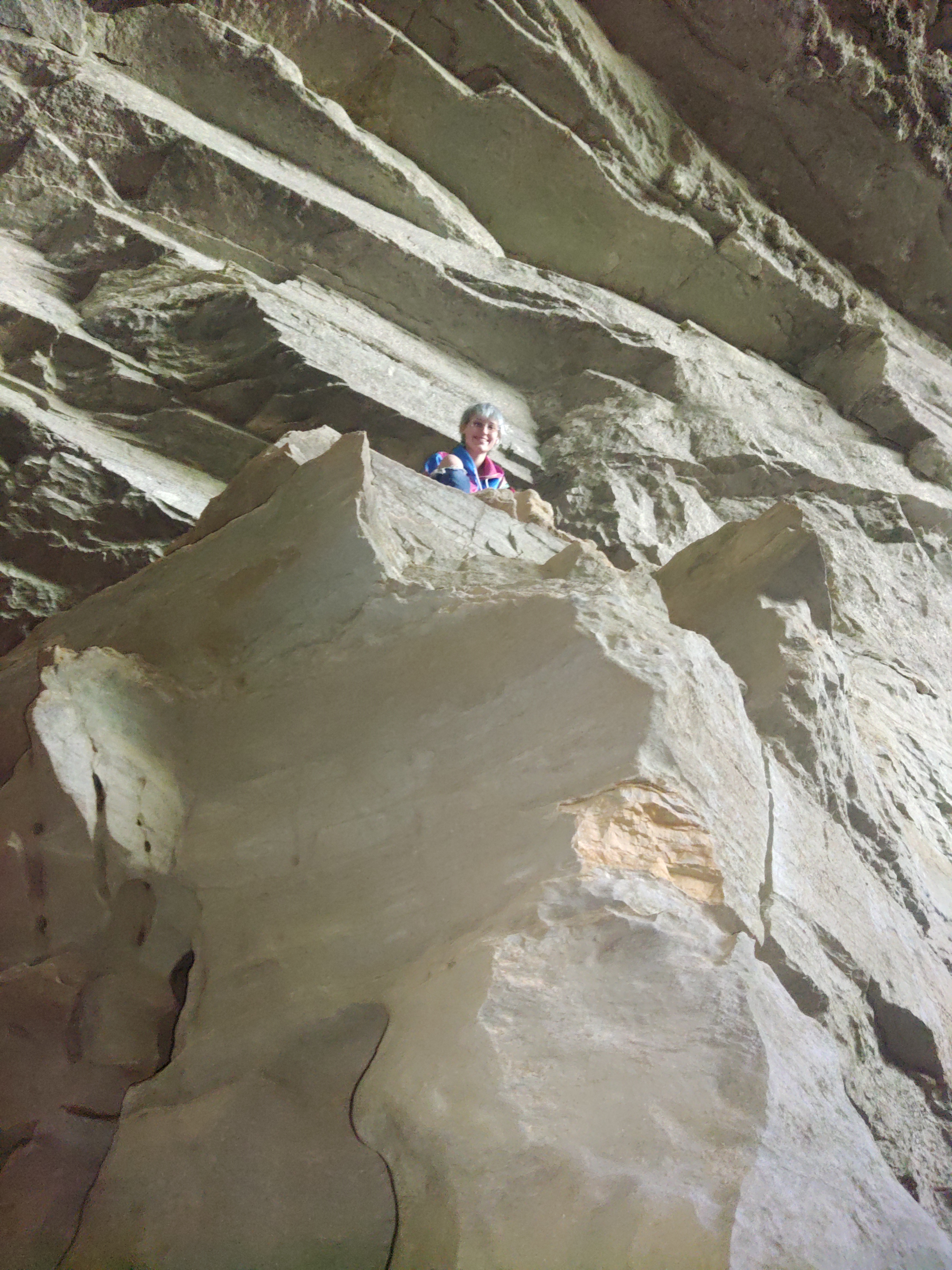
many photo ops. in Indian Rockhouse...
|
Although some books claim Cob
Cave at Lost Valley is bigger than Indian Rockhouse, I don’t believe it. This humungous shelter cave like its little brother downstream also has a big
skylight towards the right end of the shelter.
In both shelters the holes in the roof are the result of a partial
ceiling collapse, here in Indian Rockhouse the opening looks like a classic natural bridge. |
and many climbing ops. too (Jema image)
|
Once inside we head west (left) down to the back where a crystal-clear
creek flows out of a submerged cave passing beneath an upper cave. Then it flows along the west wall toward the
front of the Rockhouse before turning back to the west and disappearing
underground into another rocky cavern. |
| Indian Rockhouse entrance in background |
 |
some of the flowstone
|
We climb through sharp rock, cross the creek then up into the mouth of
the upper cave in the back corner of massive Indian Rockhouse. Inside this little cave within a cave, we head straight back maybe 60 or 70 feet before
turning on our lights and turning to the left into a ‘back room’ chamber. The walls are worn smooth the floor consists
of fine sand, and with plenty of headroom this is an easy little cave to
explore. |
| over the rocks to the creek |
 |
crystal-clear creek along west wall
|
Downstream a little toward the front of Indian Rockhouse and across the
creek appears to be a small cave up in a gap
in the shelter wall, Julz climbs up to investigate. It turns out to be a tight and muddy passage
around a corner to a dead end high above where the creek disappears underground,
and here at the end of this short cave is a window looking out on the rapids below. |
| gap along the west wall |
 |
Jema and Julz with the stalagmites
|
We head east over to the skylight passing a large area of beautiful
flowstone on the back wall, I get a couple pictures of Jema and Julz posing
with the two stalagmites near the east-center of Indian Rockhouse. At the skylight we’re almost to the east end
of the Rockhouse when a young family arrive, and we head out to open skies.
 |
skylight at east end
|
Retracing our way back on the old road along Panther Creek we come to
the intersection at the creek crossing where we leave Indian Rockhouse Trail
and enter Return Trail. Soon after
crossing a wooden bridge over a small ravine, we’re back at Sculptured Bedrock
though now we’re on the west bank of the creek.
 |
under the arching entrance
|
Then it’s on to Pebble Spring, we climb down the short spur to check it
out. Pebble Spring is so named for the tons
of small gravel deposited all around the spring in this deep little depression
surrounded on three sides by 20-25 foot bluffs.
On the fourth side flow from
the spring (both water and gravel) enters Panther Creek at a beautiful spot
with emerald pools and low bluffs.
 |
tons of gravel at Pebble Spring
|
Back up on the Return Trail we stay up above the creek meandering up and
down in and out, with some lovely views of Panther Creek’s abundance of pools
and smooth colorful rock waterslides. At the
next intersection we go right staying on Return Trail but don’t get far, here
along a little feeder stream is another gorgeous little creekside area with
small waterfalls, rock ledge overlooks, spring wildflowers and a small fairly deep pool known as The Natural
Bathtub.
 |
Panther Creek near Pebble Spring
|
Now following the little feeder stream southwest, we come to yet another
beautiful little place with a small waterfall where we cross the creek then
head up more stone steps. Continuing up
the creek, just before a small confluence, on the north bank is a very small
spring seeping out into the creek, which is completely dry above this spring,
here we meet a fat frog sitting in the cool water.
 |
small waterfall at crossing
|
Heading south we climb about 200 feet in the next 400 yards, then the
trail enters another old road. To
the left about 100 feet or so is the old quarry where the stone for the
impressive masonry works in Buffalo River State Park came from. About 40 years before the Buffalo National River, what is now known as
Buffalo Point became Buffalo River State Park thanks to the significant efforts
and hard work of the Civilian Conservation Corp, which includes the beautiful
stonework throughout the park.
 |
Julz 'playing' in the Sculptured Bedrock
|
After leaving the quarry the old road continues uphill but not nearly as
steep, we're soon topping out near the parking area/trailhead, the end of the
hike. Here at the parking area are a
couple picnic tables, we have a late lunch while we recap the day’s adventure: the loop hike was about 4 miles with 520
feet of elevation gain, lots of beautiful little secluded spots along the
creeks and the crown jewel of Buffalo
Point...massive Indian Rockhouse.
 |
lots of Dogwood all over Buffalo Point
|
Indian Rockhouse
Trail: For a map and Statistics Chart see: 78 Indian Rockhouse Buffalo
Point isn’t hard to find, at the intersection of Hwy.14/268 about 1.7 miles
north of the SR 14 bridge over the Buffalo River turn east on SR 268
(Buffalo Point Road) and go about 2.5 miles to the Indian Rockhouse Trailhead
and parking area, which is just a couple hundred yards past the ranger station
at the turn-off down to the campground and river. |
another view of Painted Bluff on the Buffalo
|


Comments