Just six days ago while hiking along the upper portion of Whitaker Creek, I
was pleasantly surprised by how easy the overall hike was (see: 167 Amber, Compton’s and Owl Falls). Having expected a steep rugged day with lots of bushwhacking, typical in wilderness
areas. Yes, I was definitely pleased with the easy hiking conditions, the scenic
beauty and magnificent waterfalls were great and lived up to the expectations .
 |
tight steep Adkins Canyon
|
That being said, today I decide to attempt
another area also in the Upper Buffalo Wilderness that I’ve been curious to see
forever but have always shied away from. Along the southwest corner of the wilderness
is Adkins Creek with lots of water features including Leaning Log Falls and
Adkins Canyon Falls. Today may be the
perfect time to check it out since we got another inch of rain just two days ago.
 |
east of trailhead on old road
|
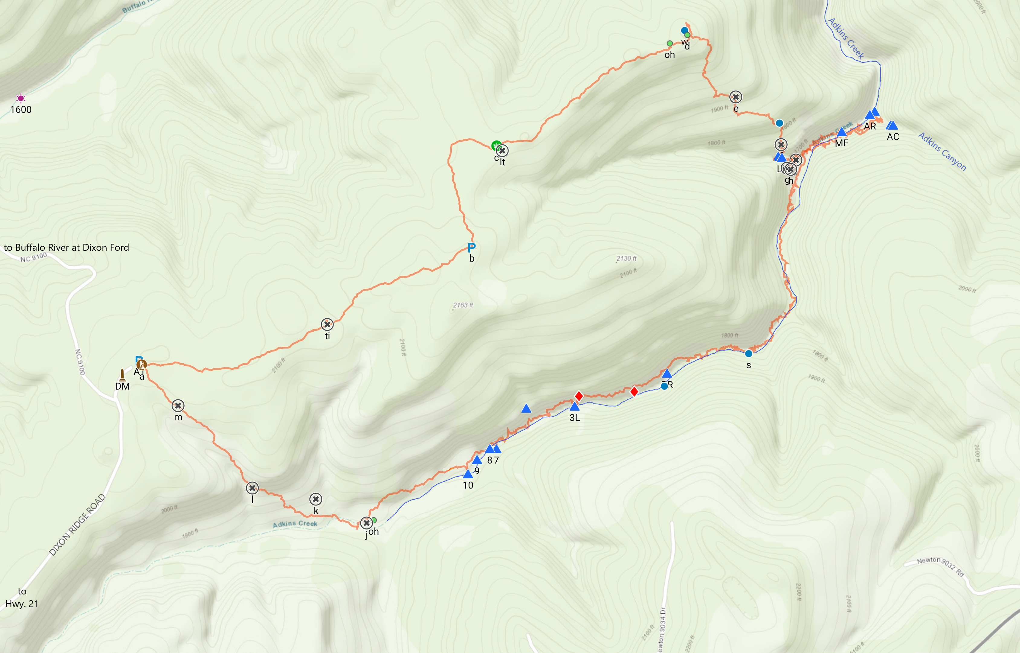
It’s a long drive from the house way up north, but I make good
time and arrive at Dahl Memorial Trailhead around 10:00. The large parking area 100 feet past the
Jerry Dahl Memorial is situated around a big old oak tree and can probably
accommodate 20 or more vehicles, but today (Saturday) I have the place all to
myself.
 |
small clearing (wildlife opening)
|
I begin my hike east on the old road (FR 92285B aka NC 9101) which is
mostly flat here on the wide ridge with Buffalo River to the north and
Adkins Creek to the south. The first three
quarters of a mile I see nothing that would prevent driving any stock 4WD on
this narrow road, a few shallow muddy ruts and mud holes is the worst of it,
all easy hiking to be sure.
 |
remnants of a fireplace
|
Near 0.4 miles is a road heading off to the north with a nice pond next
to it, then it's gently uphill to the high point of this hike at 2148 feet with a
good parking spot. Soon I come to
another intersection where this road turns sharp north with another faint road
to the south, and plenty of room for a couple more parking spots. Both of these faint old roads warrant future investigation, more hikes for another time.
 |
Upper Leaning Log Falls
|
Now going in a northerly direction for over 300 yards then a long
sweeping curve back to the east and into a small wildlife opening (old
clearing). I follow the ridge for
almost half a mile to an old homesite where the road ends. There isn’t much left of the small farm that
once occupied this lonely point at the end of the ridge. All I can find is a small foundation of
stone and a little further east the remnants of a fireplace and a few more
foundation stones.
 |
Leaning Log Falls from top of bluffline break
|
I search the area for any sign of a trail heading down the hillside but finding nothing I bushwhack down the sometimes steep hill alternating east then
south. Along the way I find a nice
little spring gushing out of the hillside under some rocks, eventually I
hear flowing water and let my ears guide me down the steep slope to the top of
Leaning Log Falls.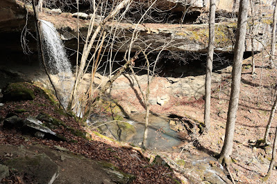 |
Leaning Log Falls from grotto level
|
Here above Leaning Log in the tight steep little canyon is a beautiful
cascading waterfall 12-15 feet tall complete with a 'leaning log'. I
take a couple pictures while trying to figure out where to go from here, across
the small fast moving creek I see what may be a trail. It seems to be my only option other than
going back the way I came down, I gingerly hop across hoping for the best.
 |
Leaning Log Falls
|
This faint trail quickly goes around a corner to an apparent dead-end on
a ledge, from there it’s a steep climb back to the left down to the level of
the long grotto that curls around behind Leaning Log Falls. Incidentally the leaning log for which the falls was named (by Tim Ernst) is long
gone. I cross behind the falls under the
long grotto then make my way down the wet mossy broken shale and mud to the
base of Leaning Log Falls.
 |
Many Finger Falls
|
This is a wonderful waterfall that Tim measures as 27 feet tall, again I
stay here awhile taking pictures and scouting
for a route down to Adkins Creek. I head
east briefly along the base of the bluff but soon climb down through lots of
large sharp rock, a descent of nearly 60 feet to Adkins Creek where I continue
climbing through lots more large sharp rock downstream.
 |
Adkins Rock Falls
|
About 200 yards downstream is pretty Many Finger Falls, a short
waterfall (about 5 feet tall) with ‘many fingers’ and luckily for me just below
the falls a rocky crossing where I can get to the south bank with dry
feet. Continuing downstream, and since it's just as
rugged as on the north bank, I climb up about 20 feet above Adkins Creek hoping
for easier hiking but no such luck.
 |
Lower Adkins Falls
|
Making my way back down to a little point perched above the confluence
of Adkins Creek and smaller Adkins Canyon, I find a spot with a relatively clear shot of Adkins Rock Falls. Another short waterfall of five or six feet
and very picturesque, I soon precariously make my way back off the perch on the
point, up then around into Adkins Canyon.
 |
Adkins Canyon Falls
|
Right away once in Adkins Canyon are views of both Lower Adkins Falls
and Adkins Canyon Falls, I follow upstream at creek level just far enough for a
good view of both falls and what a spectacular sight it is. Not counting the Lower Falls, Adkins Canyon Falls
has four or five distinct sections that have a little bit of a twist to them and
a tall cascading section in the middle
that fans out near the bottom. Lower Adkins Falls is almost 10 feet tall, and above it Adkins Canyon Falls is
listed as 42 feet.
 |
Leaning Log Falls from across Adkins Creek
|
Leaving Adkins Canyon and making my way upstream on Adkins Creek is
slow going, I stay on the south bank as far as I can then realize the trek upstream will involve many creek
crossings. I don’t bother with my waders
since these crossings often appear to be knee deep, and once my feet are wet,
what would be the point? Maybe with a
lot less water flow you might be able to easily
hike right up the creek, but today this is impossible.
 |
swift rocky Adkins Creek
|
After about half a mile of this I have lost count of how many times I’ve
crossed Adkins Creek, along the way I've seen a couple springs on both sides of
the creek. Then another short waterfall,
this one named Big Rock Falls for the big rocks on both sides restricting the
creek flow and creating the short falls, just before Big Rock Falls was my last creek crossing today.
 |
on a flat rock with a view
|
From Big Rock Falls I climb the hillside about twenty feet above creek
level hoping for some easier hiking (again) and this time it does seem to be a
little better. Trudging through the open
woods isn’t bad, but with the steep slope I’m travelling diagonally, combined
with my soaking wet socks and shoes, this is a little painful on my tender
feet. I soon take a short break on a
nice flat rock with a view of the creek below.
 |
Three Ladies Falls from up at bluffline
|
Feeling revitalized I continue
west and climb up the hill maybe another twenty feet to a low bluffline and
grotto. Here I’m above Adkins Creek
maybe 40-50 feet but still notice a nice taller waterfall, or more accurately a
plunging cascade. This is Three Ladies
Falls and even up here it looks great, it’s hard to guess the height from this
perspective although it looks pretty tall.
Since this bluff affords a bird's eye view of the falls below, I’m
calling this spot Three Ladies Bluff.
 |
nice wet weather fall
|
Continuing west I slowly head down the hillside closer to creek level
and cross a tiny drainage with a real nice wet weather fall, a sort of
multi-tiered steep cascade and it looks great today for a limited time
only. Soon back down along Adkins Creek,
thankfully the creek bank isn’t quite as rugged as it was further downstream.
 |
side stream cascade
|
Nearing a steep side stream coming in from the south is a long tumbling
cascade just upstream from the confluence with Adkins Creek. And on Adkins itself the first of three small
falls spaced out less than 200 feet apart each around three or four feet tall
and all three gorgeous, collectively these are 'Adkins Creek Cascades' and will be the last of the water features visited
today.
 |
a rare tranquil pool on Adkins Creek
|
Past the Adkins Creek Cascades somewhere on the north bank of Adkins Creek
was once a homesite, but all I find is an abundance of roses gone wild. Also, here the main west branch of Adkins
Creek goes completely dry with all the water flow coming from the south branch. Here too I begin looking for the old road
that once came down to the homestead.
 |
Bottom Falls of Adkins Cascades
|
It takes a while, heading mostly west and uphill about a hundred feet,
but I finally stumble onto the road.
After the grueling, rough and rugged trek down to Leaning Log Falls,
Adkins Canyon Falls then up Adkins Creek, this faint old road is a most welcome
sight. After landing on the road, it’s
about half a mile up to the Dahl Memorial Trailhead.
 |
Middle Falls
|
Well, this was truly an Outdoor
Adventure in the Ozarks, not an easy hike once I started down off the
ridge. This to me would be a 'difficult
bushwhack' and it took me over six hours to complete, total distance was 5.9 miles
with 973 feet of elevation gain. Back at
the truck I feel spent the hike took
it all out of me, but I still had a great time visiting some great waterfalls.
 |
Top Falls of the Adkins Cascades
|
Dahl Trailhead: Statistics Chart 168 FS 1463 or NC 9100, better known as Dixon Ridge Road is an unpaved road heading north off SR 16/21 about 1.4 miles northeast of Fallsville, or approximately 7.25 miles southwest from Edwards Junction. From the highway follow Dixon Ridge Road about 2 miles to the signed intersection for Dahl Memorial Trailhead and turn right, then it’s about 100 yards on NC 9101 to the trailhead/parking. |
| base map before fair use alterations is property of USGS--licensed under Creative Commons Attribution-Noncommercial-Share Alike 3.0 U.S. License |


Comments