We have had some much
needed rain the last few days, it didn’t amount to much, but I think today will
be a good time to see some waterfalls before everything dries-up again. I tried
to get an early start, but this morning we lost an hour before we even got up thanks to Daylight Savings Time (what a joke).
I head south through Boxley then up Cave Mountain Road to the Upper
Buffalo Wilderness.
 |
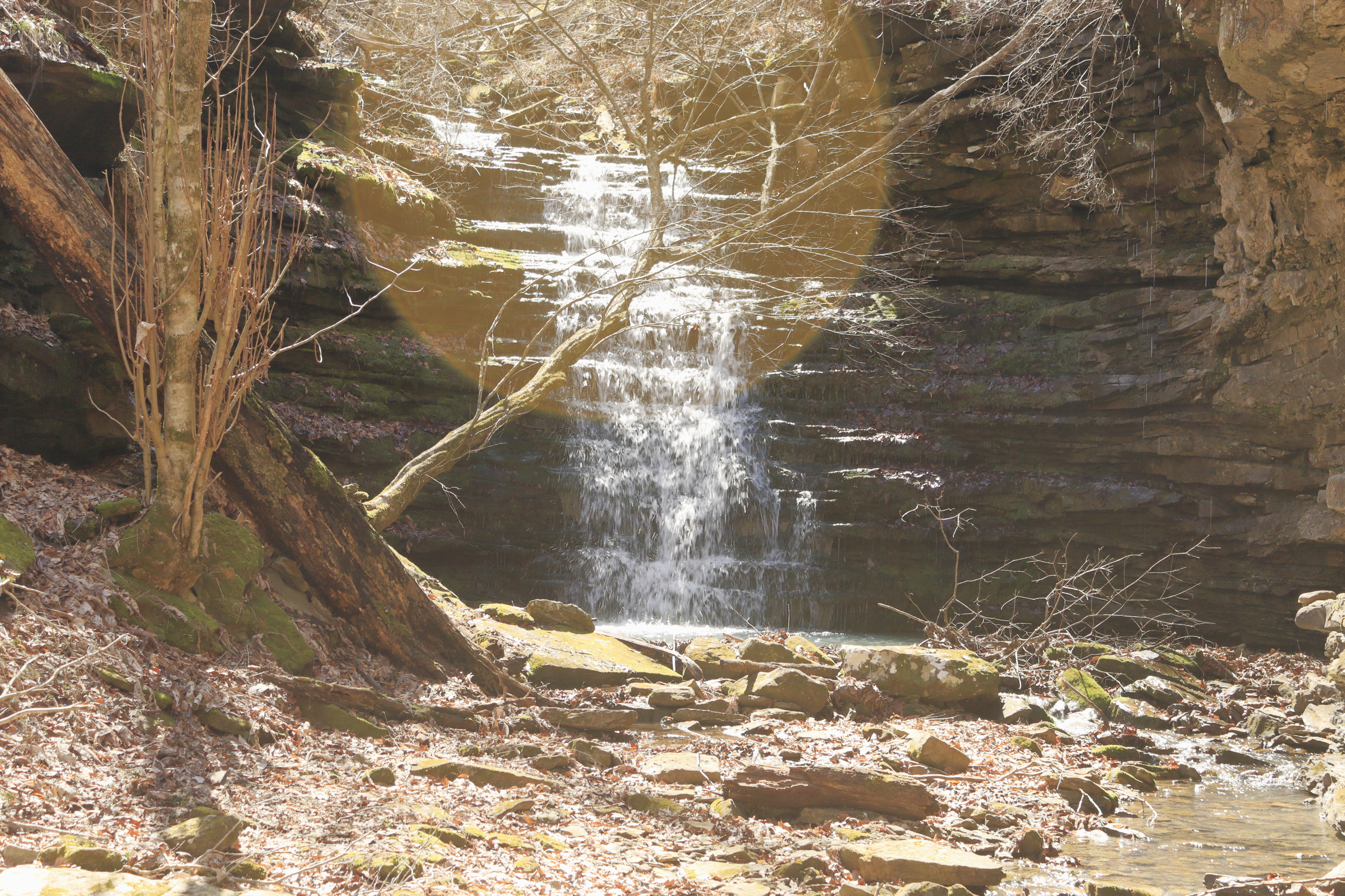
Amber Falls on Upper Whitaker Creek
|
South of Whitaker Point Trailhead parking area (see: 161 Hawksbill Crag for my most recent
hike involving fantastic waterfalls) about a mile, is a wide spot along the left
side of the road with room to park three or four cars. Just over 200 feet further is what’s left of
a wooden ‘Wilderness Area’ sign marking the trailhead. And a good trail it is, I head south zigzagging down the hill, which is
pretty steep but not too bad, and obviously well used.
 |
trailside habitat?
|
After about 260 feet of elevation loss at an intersection with multiple trail
choices, I turn right upstream and in about a hundred yards come to a short
steep bluffline break. Even before
climbing down to creek level, I can see beautiful Amber Falls framed between two
big beech trees. I’m down beside Whitaker
Creek in no time and making my way through the rocks 100 feet upstream to
the base of the falls. |
between two beech trees
|
Amber Falls is 18 feet tall (by Tim Ernst’s measurements) plunges into
a lovely turquoise pool and today is gorgeous, the recent rains have done a
good job. This gives me hope that the
other falls downstream will also have adequate
water flow for some impressive scenic beauty.
Leaving Amber Falls, it’s back up the bluffline break then to the
trail intersection. |
Amber Falls
|
Here there are a few options; left and immediately left again is northwest back
the way I came, the climb to the trailhead/parking area. Left then immediately right heads east but I
couldn’t say where it ends up, later downstream after visiting the other falls I look
for this trail but never find it. I take
the right fork which is almost straight
ahead and follows Whitaker Creek downstream. |
wet weather falls in little side drainage
|
Hiking along Whitaker Creek is a little rough but lovely, I soon come into a little side drainage flowing
down from the north and a nice wet weather fall that needs a little more rain
to get it going. Back on Whitaker Creek
is an area with four or more downed trees at the creek bank forcing some
off-trail detours before I pass below some nice, jagged bluffs and continue
east. |
on Whitaker Creek
|
Then into another little side drainage flowing down from the north, this
one more rocky and rugged than the last.
I see a waterfall up high on the creek, but it doesn’t appear to be much
more than a trickle, so I’ll pass on
this one and continue southeast down Whitaker Creek. Pretty soon the trail becomes less obvious
yet easier as it follows close to the creek on flat bedrock. |
a nice, jagged bluff
|
Along this flat bedrock are a couple small waterfalls 3 or 4 feet tall and
a few more deadwood obstacles getting in the way of clean easy hiking. Then I’m on top of Compton’s Double Falls, where the eroding forces of
flowing water through the eons has gouged
out two shallow trenches in the bedrock creating Compton’s Double Falls. From up here on top of the falls is a
wonderful view down the steep canyon of Whitaker Creek. |
one of the little falls above Compton's Double
|
But with no safe way down to the base of the falls from here, I make my
way back to the faint and quite rough trail on the north side of the
creek continuing east downstream. Along
here are many views back to Compton’s Double although partially obstructed by
tree cover. Soon arriving at a faint 3-way intersection and turning
sharp-right back to the west along the bluff of loose wet shale, I
descend to creek level. |
the Double begins here
|
Back upstream on Whitaker Creek climbing around lots of moss-covered rock it’s a good 150 yards to the base of Compton’s Double Falls with a
few good photo-ops along the way. Listed
at 39 feet tall Compton’s Double is both unique and beautiful, today the right
fall has more water flow than the left, from pictures I’ve seen this seems
to be ‘normal’ and undoubtedly an awesome sight. |
Whitaker Creek from the top of Compton's Double
|
Compton’s Double also has a great blue/green pool at its base and is a hard
place to pull away from, so I linger quite a while taking pictures and a short
rest. Then it’s downstream on the south
bank about 200 yards with loads of umbrella magnolia (no sign of leaves yet) to
a little creek flowing down from the south.
I turn here and head upstream not far to Owl Falls. |
Compton's Double Falls
|
This tight little canyon stream seems to feature lots of loose rock
underfoot so slow and careful seems to be
the way forward. But it isn’t far, in fact I
notice Owl Falls up ahead as soon as I turn up into the little canyon. Owl Falls is a steep cascading waterfall off
dark crumbling shale, by my estimate 15 feet tall ‘give or take’ and quite
impressive. |
Compton's Double from a different perspective
|
Apparently, I arrive at Owl Falls at exactly the wrong time of day (blame
it on daylight savings time change), the harsh sunlight makes getting a descent
picture about impossible. I try different
camera settings and even a filter to darken the glare, but with limited success
all my shots have varying intensities
of ‘corona’. I could wait it out for better lighting later this
afternoon, but I don’t have the patience for that. |
awe inspiring Compton's Double Falls
|
Instead, I head back down to Whitaker Creek then upstream to an easy spot
to cross keeping my feet dry, up the loose shale along the bluff before arriving
at that faint 3-way mentioned
above. From here rather than returning
the way I came, I head uphill to the east thinking this will soon turn
back to the west and connect with the higher trail seen earlier after visiting Amber Falls. This doesn’t happen, the faint trail just vanishes so I’m left to my own devices, in the open woods. |
Whitaker Creek near crossing
|
With no trail, I keep heading west and occasionally north trying to gradually gain altitude. Soon I pass through a large spread-out rock
garden, then later a low bluffline which I eventually reach the top. I also cross the two little drainages with the wet weather falls that I crossed earlier far below. And another low bluff which I end up on top
of, and finally after about a mile of bushwhacking, I come to the trail and turn north
back up to the trailhead. |
Owl Falls with corona highlight
|
Today was a good time for an outdoor
adventure in the Ozarks with enough recent rainfall to make the three main event waterfalls all look great without creek crossings becoming hazardous. The trail for the most part was in great shape, and bushwhacking through the open woods was easy. The total distance hiked was less than I
expected at only 3 miles that included 655 feet of elevation gain. |
Owl Falls
|
Whitaker Creek: Statistics Chart 167 The meager roadside parking on
the left is about 7 miles up Cave Mountain Road if you turn off SR 21 just
north of the Buffalo River bridge. If you’re coming from the south, you can turn
north off SR 16 near the big 'Upper Buffalo Mountain Bike Trails' sign onto
Cave Mountain Road, then about 6 miles to the parking area on the right side of
the road. |
base map before fair use alterations is property of USGS-licensed under Creative Commons Attribution-Noncommercial-Share Alike 3.0 U.S. License
|
|


Comments