So far the new year has been cold
and wet, when it isn’t snowing we’re getting lots of rain. Today begins sunny and a little warmer, maybe
a good day to look for waterfalls. I leave
the house and head south around 9:30 right after the temperature climbs above
freezing, and land at the Richland Creek Trailhead for the Ozark Highlands
Trail.
 |
Fat Lip Falls
|
Richland Creek Trailhead just north
of the concrete bridge over Richland Creek, is clearly marked and has a newer sign-in box. The trailhead marks the start of what I call ‘section 20’ of the OHT from Richland Creek Trailhead to Stack Rock
Trailhead a distance of about 7.5 miles.
I plan to go as far as Long Branch before turning around and coming
back.
 |
Richland Creek Trailhead
|
Back in early November I hiked
‘section 19’ on the OHT and found the trail (with the exception of the steep Landslide Bypass) to be in excellent condition, for those adventures see: (150 Campground Trailhead,
and 151 Falling Water Trailhead). Today, the trail here is also in great
condition and well blazed, although a little mundane here to start.
 |
scenic rugged point
|
Heading out northeast it’s easy
hiking to be sure, but what I find disappointing is that Richland Creek is so
far off the trail, at the trailhead is possibly the closest point to the river. I can clearly hear the rushing waters over
the many rapids far below through the woods but rarely catch a glimpse of the
creek. Also, occasionally I’ll spot the
old road down below that follows close to Richland, hmm... maybe I’ll find a way down to the road on the way out.
 |
short rock wall
|
After a sweeping curve to the northwest
the trail gets much more interesting after entering an old road, from 30-50 feet
to the edge of the bluffline the views of Richland Creek below open up
dramatically. With all the recent
precipitation I cross a couple very tall wet weather falls, although here on
the top I can’t actually see the falls.
 |
stonework reservoir?
|
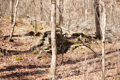
The bluffs don’t last long, about a
quarter mile later and right next to the trail is a short segment of an old
rock wall, evidently there once was a homestead here long ago. Just 100 feet further at a small creek is an
abundance of stonework in and at the edges of the little stream. My only guess is this was possibly a
reservoir built to provide year-round water to the nearby home.
 |
no horses on the OHT
|
Past the little creek stonework, I
soon enter a large boulder field with giant rocks all around. Then come two more wet creek crossings, I
have lost count how many wet crossings I’ve had today but all have been easy,
across on mostly dry stone. The last of these is sort of unusual as
multiple small streams are seeping
from a huge rock jumble before combining into a single little creek and flowing
down the steep hillside.
 |
in the boulder field
|
Now hearing flowing water up ahead,
I must be getting close to Long Branch, easily the biggest drainage crossing the
OHT along this southern portion of
section 20 and is also my intended turn around point (for more Long Branch exploration see: 197 Long Branch Loop). I leave the Ozark Highlands Trail before
reaching Long Branch and head downhill toward the confluence of Long Branch
with Richland Creek. Not bad at first,
it gets steeper as I go.
 |
OHT mile marker
|
Twenty feet up on a drop-off ledge above
Richland Creek I angle my way back north and down the steep slope into rock
strewn Long Branch. Now I’m climbing
over and around lots of big sharp rocks heading upstream along numerous
little falls and cascades. Soon I catch
a peek of a nice waterfall maybe a
hundred feet ahead and about the same time get my feet tangled in a grapevine,
falling face first.
 |
above confluence of Long Branch and Richland
|
My upper lip takes the worst of it,
getting busted on a sharp rock, I’m just glad I didn’t chip a tooth. Once up and on my feet, I spit a little blood
then continue (more cautiously now) upstream to the waterfall. This is a beautiful little fall, 8-10 feet
tall and when at its best maybe eight feet wide. I thought about calling it Lower Long Branch
Falls, but that’s a little too generic
I’ll call it Fat Lip Falls instead.
 |
rugged Long Branch
|
I hang out here for a while admiring gorgeous little Fat Lip Falls licking my wounds and have some
lunch, I'd bet this steep lower half mile of Long Branch has a few more impressive waterfalls. Then after taking a few pictures, instead of backtracking the way I came down I climb up the steep gorge west back to the little ridge then uphill to the Ozark Highlands Trail.
 |
Fat Lip Falls
|
Nice to be back on an actual trail
the mileage goes by pretty quick, soon I’m back on the old road and at the
point where the OHT leaves the road up a gentle hill to the right. But I choose to stay on the road, hoping my
return route will include some great views of Richland Creek. This old road is a little steep to begin and very washed
out also has one big downed tree to detour around, but all-in-all not a bad choice.
 |
upstream on Richland Creek
|
In just under 300 yards, I’m at the
bottom of the hill at an intersection with a better and flatter road. At this
T-intersection are a few handmade signs nailed on nearby trees pointing the way
to ‘Richland Campground’ and landmarks I’m not familiar with such as ‘Moss
Rock Campsite’ among others. I turn
right, upstream along fabulous Richland Creek.
 |
rocky Richland Creek
|
Now closer to Richland Creek
there are lots of places with decent
views of the raging river and soon I find an easy place to get down
next to the water for some photos. Right
here at the edge of Richland Creek is a giant flat-topped boulder with thick
moss on the top. I find a way up to the
top for some unobstructed shots of the river, this is a great spot I’ll call
‘Richland Moss Rock’ just because it is...
 |
a better stretch of old road
|
Continuing west the old road gets
muddier as I go, before long I come to a small campsite with fire ring between
road and river and a flat clean tent area across the road. Then more mud and even some areas of flowing
water down the roadway, also a few muddy detours that I avoid since they don’t
look any better than the real
road. This is the routine for almost a
quarter mile until I arrive at my truck parked next to the Richland Creek Trailhead.
 |
lower Long Branch
|
It seems the Ozark Highlands Trail
always provides a great hiking experience wherever you choose to go, and I had
a great time today busting my lip and finding a new waterfall. Getting in and out of the Long
Branch gorge wasn't easy, but other than that this was an wonderful hike of
5.3 miles and 640 feet of elevation gain.
 |
Richland Creek
|
OHT Richland Creek: Statistics Chart 159 The wilderness can be accessed from all directions, which you choose largely depends on where you're coming from. Today I came in from the north, first I drove SR 74 out of Mount Judea to Bass which is where the pavement ends. At the south end of Bass where a new bridge is going in, cross Cave Creek on NC 5070 (some maps call this road Cave Creek Rd. on others it's Bass Rd.).
 |
on Richland Moss Rock
|
Stay on NC 5070 up the mountain to the 3-way northwest corner of Richland Creek Wilderness. Here veer to the left on NC 5080, passing Iceledo Gap then Dickey Junction. Then you'll cross the county line where the road changes names to SC 1, better known as FR 1205 or Falling Water Road. Continue south to OHT Richland Creek Trailhead parking area on your left, before coming to the Richland Creek concrete bridge.
 |
| base map before fair use alterations is property of USFS-licensed under Creative Commons Attribution-Noncommercial-Share Alike 3.0 U.S. License |


Comments