Lately on my hiking excursions I have put a lot of miles on the truck
getting to and from my chosen destinations, and in the process have passed by loads of good hiking areas. On my last
three hiking adventures I have driven over 100 miles round-trip to each
location. So today I’m going down to
Hiner Hole, one of our favorite swimming holes, to hike a short section of the
Old River Trail, which should cut my travel time and mileage in half.
 |
overhang bluff at Leypoldt Hole
|
The road from Scenic Highway 7 to Hiner Hole is NC 2890 and it always seems
to be in poor condition this morning is no different, just over an inch of
rain in the last 24 hours doesn’t help.
All eight of the creek crossings have flowing water, one is a little
muddy all the rest are across solid bedrock so no problem. A couple areas have water flowing down the
road and there’s lots of tree debris on the road too, all this makes for an
enjoyable 4X4 drive of around 3.5 miles.
 |
high water at Hiner Hole
|
I park about half way down the Hiner Hole access road, which from top to
bottom is 400 yards. There I meet a
young man from Kingston packing up camp after a weekend camping and hunting
with friends. He reminds me to wear some
hunter orange, better safe than sorry and good advice, I don’t argue. I walk down the road to the Buffalo River,
I’m curious to see what the recent rains look
like in the river. |
little ledge falls
|
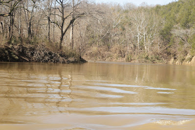
The Buffalo is high brown and moving fast, more alarming though is all the
trees piled up everywhere along the gravel bar.
Many of the nice leaning sycamore trees that we set up camp under when
swimming here are gone and all the sand is also gone (see: 123 Toes in the Sand).
I know all this damage isn’t the result of our most recent rains, but
the big three day storm that dumped over a foot of rain two weeks ago.
 |
another small falls
|
Just up the bank about 100 feet from where the ORT crosses the river, is
a trail heading north. I walked up this trail a short way in my sandals back in
the summer when we were here swimming.
Today I’m going to find out where it goes, not a hundred feet from
the ORT is a campsite that I didn’t notice in the summer. The trail follows the river downstream but up
above the bank far enough that I rarely see it, I sure can hear the fast
current though.
 |
| easy to follow ORT |
 |
sunny hillside
|
Down here close to the river the trail is a little muddy and overgrown,
soon I come to a creek crossing in a deep ravine where it gets real muddy. Up the other side the trail turns west away
from the river and climbs a little hill where it lands on an old road trace and
the hiking conditions improve dramatically.
But right away I hear ‘falling water’ down on the creek I just crossed,
I angle my way down to a nice six foot ledge waterfall.
 |
where trail crosses river
|
It will take a lot more than one inch of rain to get this tiny creek
moving, but there’s enough flow to get the idea. I head back up to the old road
to find a locked gate and just beyond a nice flat area for camping. Then I’m on the road (NC 2890) I drove in on,
and soon back at the Hiner Hole access road.
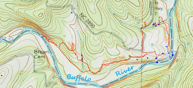
Well now I know where the trail goes, it’s a short loop of just 1.1 miles
with 73 feet of elevation gain, that I’ll call ‘Hiner Loop’.
 |
Buffalo River @ Leypoldt Hole
|
After a snack at the truck I head west on the Old River Trail which is
in great shape, a little wet today but not muddy. Along the way are a few meadow areas that were probably once fields, and a couple places I
pass some obscure homesite locations but don’t find much more than some rusty
body parts from old vehicles. A
little farther an old washing machine off the trail seems really out of place.
 |
bluff near river
|
Soon a side trail branches off to the north, I stay on the ORT which
drops into a little gully and across a creek.
On the other side a bluffline begins to slowly rise on my right and once again I can clearly hear the rapid
water flowing down the Buffalo just out of sight to the left. The trail follows these low bluffs to the
river, along the way passing another trail heading north. I decide to explore this side trail on my way
back, first I’ll check out the Buffalo just ahead.
 |
see the pigeons?
|
Where the Old River Trail crosses the Buffalo is at the downstream end
of Leypoldt Hole. The river here at the
bluffline is forced into a turn and over time has undercut a deep gouge in
the sandstone bluff, today the fast brown Buffalo at the ORT crossing is easily
100 feet wide. Under the overhanging
bluff some pigeons have made their home about ten feet above the rushing river
on a small protected ledge.
 |
dark water streaked bluff
|
Looking at the map before I began this hike today, I knew Leypoldt Hole
would be my turn around point. Here the
high fast flowing water is the primary obstacle
to continuing west on the trail, surprisingly the river banks are washed clean
of deadwood debris. Unlike downstream at
the ORT crossing below Hiner Hole where trees are piled up all around the trail
crossing. I head back east 200 yards to
that side trail heading north.
 |
near east end of bluff
|
Leaving the ORT this side trail starts climbing the hill immediately,
not too steep but a good cardio workout.
After about a seventy foot ascent the trail levels out and turns to the
southeast below the ridge, and gets pretty faint for a short time. Maps show a cemetery up on this ridge, but if
there is a trail to the cemetery I must have missed it, as now the trail begins
to descend into a small drainage and more small sunny meadow areas.
 |
trail crosses on little ledge
|
After passing a rock pile next to the trail, I head downhill to the
little creek and cross on a solid bedrock ledge with a short two foot waterfall
just below the trail. Maybe thirty feet
above the trail another waterfall this one about four feet tall flowing over
travertine style stacked stone. And
above this waterfall a third fall of six feet off rounded smooth rock, this one
with two tiers and an old fence line across the top.
 |
travertine falls
|
Continuing southeast the descent is gentle down to the Old River Trail
which isn’t far. From here the trail
stays pretty flat the half mile or so back to the parking spot on Hiner Hole
Road, and doesn’t take long. This short
hike on the ORT between Hiner and Leypoldt Holes was completely enjoyable on
this beautiful fall day, roundtrip was only 2.4 miles with 219 feet of
elevation gain, that’s a total for the day of 3.5 miles and 292 feet gain.
 |
fence line falls
|
ORT: Hiner to Leypoldt Statistics Chart 183 From SR 7 just north of the Buffalo
River bridge take NC 2890 west for 3.4 miles to where the road makes a 90° turn
to the right. Continue straight onto an
old road (Hiner Hole access road and ORT). This
road curves around to the east then heads downhill, nothing steep but there are
two places where the road has washed out leaving deep uneven ruts (high
clearance and 4-WD recommended). There
are six or more parking spots along this road.
 |
base map before fair use alterations is property of USGS--licensed under Creative Commons Attribution-Noncommercial-Share Alike 3.0 U.S. License
|


Comments