123 Toes In the Sand
Always looking for new swimming holes, I often use Kenneth Smith’s ‘Buffalo River Handbook’ along with four different maps of the Buffalo River region, all the maps are different as far as location and existence of roads and trails. Transposing swimming hole locations from Ken Smith’s book to the maps, I have ‘found’ four more possibly accessible swimming holes upriver from Pruitt.
Today we’ll hopefully find one that’s a nice peaceful place to relax on the river. Only one map shows any roads leading back to these swimming holes, and all these holes are farther upriver than any hole we have visited in the past. So, hopefully we will be able to get to one having enough water to swim, I’ll keep my fingers crossed.
Travelling south on Highway 7 just north of the river before coming to the bridge is NC 2890 off to the west (right), we turn here on the paved road. The pavement only lasts to the top of the hill where the road narrows and becomes pretty rough. Following NC 2890 for 3.4 miles we wind in and out of side drainages, over dry bedrock creeks, up and down hills then where the road makes a 90° turn to the right, we continue straight onto an old road which appears to get as much use as the county road.
 |
| Hiner Hole looking north |
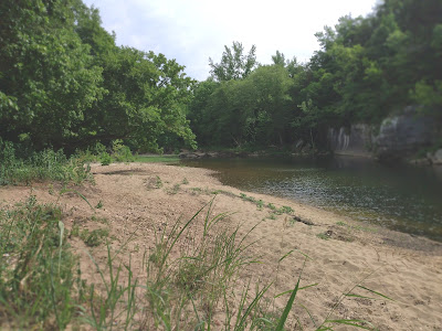
Only about 30 feet down an easy and clear trail from our parking spot is Hiner Hole which is about half a mile upstream from river mile: 50 and Ozark Campground. ‘Hiner Hole’ is named after Les Hiner who once owned and operated a dairy farm on this land before it was bought by the National Park. We setup our camp under a small sycamore in the sand near the downstream end of the hole.
 |
| sandy beach of Hiner Hole |
After pinching myself several times to make sure this isn’t a dream, I pull my toes out of the sand and take the short walk to the river to check out the swimming conditions. The hole is as perfect as the beach, walking in, the water deepens pretty quick: up to my knees in four steps, twelve steps up to my elbows. Then it gets deep, deeper I think than any swimming hole where I have estimated depth.
Out past the middle about twenty feet from the bluff I repeatedly try to reach the bottom without success, and I’m wearing flippers to aid getting to the bottom. In one place however I am able to reach bottom on top of a huge round boulder submerged at a depth of approximately 15 feet. That’s to the top of the rock, so the hole is even deeper, I’ll estimate Hiner Hole to be 3-4 fathoms deep (break out the scuba gear).
 |
| 'the good life' |
Back in my beach chair with my bare feet in the sand I start thinking this just may be the proverbial ‘perfect swimming hole’ we’ve been looking for. But before passing judgement I should go exploring, slipping on my sandals I head south on the gravel bar. As I mentioned above, the gravel bar isn’t real big, nowhere more than fifty feet to the water’s edge (of course that’s contingent on river level), walking around the bend I spot a big boulder at rivers edge about 100 yards farther upstream.
 |
| bluff above Hiner Hole |
This campsite doesn’t look to have been used in years but it’s big a ‘group campsite’. Anyway, south of the camping area are some old rusty car parts piled up in a couple places, then a little further south a ledge vista on top of a low bluff above the river. It’s a nice view upriver that will be even better after the leaves are gone.
Continuing back down the road I see a couple more parking areas along the way, plenty of parking places for 15-20 vehicles easily (total in 4 separate areas). But Hiner Hole isn’t that big, if there were fifteen cars here the hole would be way too crowded.
 |
| Swiss cheese |
Also at the bend, Hiner Hole seems to end getting shallow but no shoal here, the river is 2-3 feet deep. I turn around and float downstream along the base of the bluff checking out the various plants clinging to the sheer wall. Here along the wall is the sound of ‘gurgling’ water, like a cavity or tiny cave in the rock has some water ‘sloshing’ around inside.
Exploring downstream a little further to about where the river turns left leaving the bluffline, here is a big slanting slab of rock on the bank. It looks possible to exit the river here and hike along the base of the bluff going north but I turn back heading to camp, it’s time for some lunch.
 |
| grassy exit shoal |
Popularity definitely scores a 5, we never saw a single soul all day, we never even heard anybody. Amenities again a solid 5, a perfect beach with lots of sand and shade along with a perfect swimming hole with a sandy ‘barefoot’ access and nice deep bottom.
Accessibility is the only area where some points could be lost, the 3.4 miles on the county road aren’t bad but not good either, or the short 0.2-mile access road definitely isn’t very good but it’s passable as long as you go slow, 4WD doesn’t hurt. To be fair only a 3 for accessibility, and a plus for all the little interesting things around the hole like the big campsite with a vista, the little grassy exit shoal and the beautiful bluffline. The total score for impressive Hiner Hole: 13+.
Comments