Most folks who go hiking in the Ozarks, know old roads make good
hiking routes, many established trails follow these old roads. The thing that seems strange to me, why do ‘map makers’ choose not to show old roads in
wilderness areas? The roads didn’t just
disappear when the wilderness designation was approved by congress, and since
they do make for some great hiking, why remove them from the maps? Today I’m going hiking assuming
that an old road exists between Clabber Creek and Cedar Creek along the Buffalo
River at the edge of the Lower Buffalo Wilderness, hopefully I’m right, otherwise this will be a long day.
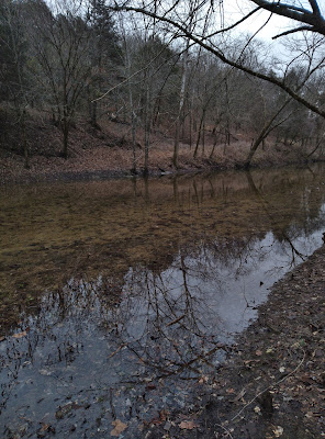 |
Clabber Creek at Crossing
|
Down at the bottom of Rush Road past the canoe launch area, I drive the
road as far as I can. Going
through some deep mud holes along the way I park at ‘Rush parking
area 4’ on a leveled hill above the confluence of Clabber Creek at the Buffalo
River. From here in the parking lot, I
see the Buffalo is running high, fast and
dirty from heavy rains upriver. I
can clearly hear the roar of Clabber
Shoal over 500 feet away.
 |
on the gravel bar
|
Walking north from the parking area on the access road it’s less than
100 yards to two cable gates, the left gate is the trailhead for Clabber Creek Trail, which is a wonderful trail to
explore, see: (77 Rush Mountain...),
the gate on the right, is to the much less used Laffoon Trail. I follow Laffoon Trail on an old road gently
downhill just over 100 yards to Clabber Creek, here the old road crosses the
wide creek diagonally, making the 30 foot wide creek, a crossing of over 50
feet.
 |
near the bluffline
|
As I slip on my creek waders
I’m looking out across the creek and say to myself ‘this looks too deep for
waders, I should have brought water
sandals’. Sure enough, it is too
deep, up over my knees the water comes in over the top of the waders, at least
it isn’t cold, I’ll be hiking with wet feet for the next hour or more. Across Clabber Creek the old road heads back south, this is easy hiking even the creek crossing was
easy. But when the road disappears on
the gravel bar near the banks of the Buffalo the easy hike turns rough.
 |
high water on the Buffalo
|
I thought gravel bars were supposed to be nice and easy to hike across,
not this one. At the head of the gravel
bar the Buffalo makes a sharp right turn then enters Clabber Shoal, so all the
debris floating down the river is deposited right here. There are large, downed trees piled-up everywhere along
with gouged out pools making it difficult hiking, I slowly make my way
up to the base of the bluff along the top of the gravel bar.
 |
beaver activity
|
Along the bluff isn’t any better with all the greenbrier and other
undergrowth, but I trudge on as best I can.
After maybe 100 yards I back down off the edge of the bluff about twenty
feet or so and find an overgrown trail running roughly parallel to the
river. Although still overgrown, at
least there isn’t much greenbrier, I soon come into an active beaver area with
cut trees and beaver trails crisscrossing back and forth to and from the
river. After close to a half mile of
this the faint trail heads up hill a little and enters an old road.
 |
on an old road
|
Once on the road the hike is easy, heading north only
about a hundred feet then the road swings around to the east and crosses a
small (dry) creek while continuing uphill.
It’s an easy grade, nothing steep, just up and down gentle slopes for the
next half mile. Somewhere along here an
old crumpled down fence line appears along the south side of the road, I
reach an area of downed trees on the road, most I can step over,
but a couple newer falls require short detours.
A little farther the road approaches to within a few feet of the rocky point.
 |
rocky point at road
|
Just past the point of the bluff covered
in green moss, the road swings to the north and descends along Cabin Creek. Staying on the road I come to the banks
of the creek at a beautiful spot with little waterfalls upstream and
down along with some gorgeous pools. The
crossing is easy to rock hop without getting my feet wet, which are finally
starting to feel dry. Once across, the
road heads south back uphill.
Now east bound the road levels out and another hundred yards I arrive at
the entrance to Cabin Creek Cemetery aka Laffoon Cemetery.
 |
Cabin Creek
|
Long ago this graveyard was fenced in to keep livestock out, but now
most of the fence is trampled underfoot.
What remains is an arch opening made of two cedars, where there once was
a gate, with a rusty sign attached at the top.
Inside is a good-sized cemetery with probably fifty gravesites, maybe more. Of
the stones that can be read most are from the Laffoon and Patterson families
although the biggest headstone has the name Smith and is off by itself near the
east end of the cemetery. From the south
side of the graveyard are some nice views of the Buffalo River 40 or 50 feet
down the hill.
 |
Laffoon Cemetery
|
For the next quarter mile past Laffoon Cemetery the road heads northeast
and is pretty flat, then follows along the base of a low bluff. Again, the bluffline has quite a bit of
undergrowth, but nothing as thick as back there closer to Clabber
Creek, and it doesn’t last long. Soon
the road turns to the north a little more and heads uphill for the next 100
yards crossing a tiny creek along the way. At the next gradual curve back to the east
the road levels out after a short descent around another little dry creek.
 |
old homesite
|
Less than a quarter mile further I arrive at the concrete and stone
ruins of an old homesite with a small outbuilding just west of the house. This is familiar ground, we discovered these
ruins back in August of 2020 when we drove in here looking for a nice, secluded swimming hole, see: (62 Cedar Creek Hole). After looking around at the rusty debris of
the old homesite I continue the last 100 yards on the old road to Cedar Creek
Road.
 |
Cedar Creek Road
|
I turn south on Cedar Creek Road and in about 200 feet arrive on the banks of the Buffalo River at roads end. About twenty feet above the river is a flat sandy turnaround area probably
big enough for three vehicles to park without blocking anyone in. Today the Buffalo River is big fast and
brown, nothing like I remember from that hot August day over two years ago when
the river was a lazy deep hole with lots of snakes and some big fish along with
a big dead tree wedged against the bank
in the mouth of Cedar Creek. The tree is long gone but just downstream are two sets of rapids around a small low
island in the middle of the river
right where it makes a sharp turn to the right.
 |
Cedar Creek
|
This sharp turn in the Buffalo is the ‘bill’ of the ‘Duck Head’
(aka 7-mile bend), and just beyond I can make out the hills rising above the
confluence of Boat Creek, although I can’t see the creek itself. Here at the end of Cedar Creek Road is a
large log that makes a nice bench for a little break. Before heading back, I scramble down a short
trail and take a couple quick pics of Cedar Creek, here so close to the Buffalo
it's a lovely bedrock bottomed, straight, calm lagoon.
 |
Buffalo River at Cedar Creek Hole
|
Heading back to Rush, I pretty much retrace the route I came in, except
when I reach the long bluffline before Clabber Creek I stay up tight
to the bluff to avoid the hazards down on the gravel bar, though the hazards of
underbrush and greenbrier up tight to the bluff aren’t much better. At the end of the bluff with Clabber Creek
coming down in the distance I soon stumble onto a pretty good trail which
starts to head downhill towards the north. Where this trail enters the old road is a rusty one-gallon gas can, to mark the spot, from here I’m back on the old road and just about 100 feet to Clabber Creek crossing. Knowing now
how deep the creek is I don’t bother with the waders but roll up my pants and
wade across, the water feels good as this afternoon has warmed up to around eighty degrees.
Today was another great day in the great outdoors and
I’m glad my assumption about the old road proved to be correct, the hike overall was pretty easy, with the exception of just about a quarter mile of rough
bushwhacking along the bluffline and gravel bar past Clabber Creek. My totals for today were 6 miles with
680 feet of elevation gain. This hike
could just as easily start at the end of Cedar Creek Road (MC 6460), that is if your vehicle is up for
it.
 |
| base map before fair use alterations is property of USGS Topo--licensed under Creative Commons Attribution-Noncommercial-Share Alike 3.0 U.S. License |


Comments