Another place that's pretty well known to rock-climbers but
not so much to hikers is Cave Creek Bluffs. This long bluffline can easily be divided up into 4-5 sections, today we're going to the central portion of Cave Creek Bluffs. South of the entrance into Sam’s Throne is an old road on the left, not in the
best shape, but it’s under a quarter mile to the ‘prime’ parking area. It’s a pretty big area with room for
maybe ten cars, and a campsite on the south side of the road.
 |
distant vista from bluff top
|
Right at the campsite a good trail heads west, only about 200 yards down this trail is the top of the bluffs
and a nice long bear-crack to the bottom.
While the slope of the bear-crack doesn’t look too bad down close to the
bottom, here at the top it is very steep. It’s all good though, we aren’t climbing down here, this is
where we’ll climb out at the end of our hike later. Danny Hale recommends to
tie a rope here at the top of the bear-crack, toss the end down, then
find it below later for an easier exit. Without the rope this climb
would be pretty dangerous near the top, but with the rope I think
it’s going to be fun. Having tied our rope to a tree we head back up the trail first to a small rock patio at the
edge of the bluff with a fantastic view of the valley with some nice fall colors
that are starting to kick-in, then back to the parking area.
 |
pre-planning for an easy exit
|
We hike down the road from the parking area about 200 yards to another
smaller parking/campsite area, in the back of the campsite on the
south side of the road a faint trail goes southeast 100 feet or so to a green ’62
Ford Galaxie. Past the car the ‘trail’
becomes harder to find, we plug away in a southeast direction and
soon stumble into a nice campsite and 100 feet beyond another great view off the top of the bluff. |
'62 Galaxie 500
|
From here we circle around northeast into a tiny dry drainage and a bluffline break along a low bluff. Down through this bluffline we come to not one but two
bear-cracks. One going west is steep and
narrow, the other goes east wider and not as steep. Naturally I take the easier choice,
wrong choice, the easy descent leaves me at a dead-end on a ledge with nowhere
to go except back the way I came, up the easy bear-crack.
 |
Kat in the crack
|
Kat has been waiting patiently for me at the top, she seems to have an intuition
about these things. We both head down
the steeper and narrow west bear-crack, it’s not long though only about twenty feet
from top to bottom. Now at the base of the bluffs we wade through lots of loose sharp rock back to the west then south and a small cave with a nice waterfall in front of it, although today without much water the falls are just a vertical streak of green moss with a trickle of water. |
a snug fit
|
Rough hiking conditions continue, we pass
four or five interesting iron ore deposits in the bluff wall that resemble size
14 tennis-shoe footprints, and slowly after another 100 yards is a cave. This nice cave is much larger than the first
and we can actually walk around inside and explore. Past the cave the bluffline curves
back leading us to the west, then up the bluff ten feet is another small
cave that we pass by since it’s small and doesn’t look too easy to get up to. |
moss falls
|
Not far from there we come to another choice: on the right near
the bluff is a big slab of rock standing vertically with just enough room
between to squeeze through and down a steep little hill maybe six feet or go
around this vertical slab on the left down through some loose rock and thick
brush. I choose the brush to the left,
Kat takes the clearer squeeze on the right. Her intuition is wrong this time, halfway through between bluff
and vertical rock she brushes against a crack about two inches wide in the
slab of rock that contains a hidden beehive. |
interesting ore deposits
|
The little devils swarm from the crack for an attack, Kat
yells “Somethings biting me!” and begins
swatting and smacking at bees. Now I
see them, they are swarming and dive-bombing all around her, I grab her by
the hand and run down the loose rock in front of the bluffline attempting to
get away from the nest. We stop about 25
feet past their nest but they’re still stinging, now I’m getting stung too.
 |
at the back of cave #2
|
We run another 30 feet swatting
at bees the whole way. The majority of
the swarm has now backed off and returns to the nest, we mercilessly crush the
few remaining determined attackers. Both
of us are obviously in pain, I try to block the pain from my mind (since there’s
nothing I can do about it) and trudge onward, she is in a much worse place, her
pain is taking over. I coax her along telling her to keep moving so the venom
will dissipate with time and motion.
 |
nice cave
|
It’s
no wonder she’s in worse shape than me, and it has nothing to do with
‘toughness’. Later when we get and do some first aid and injury assessment, we’ll find she has twice as
many stings as I have. Also, later I tell
the story to a couple of our neighbors and describe the culprits as being a little smaller and brighter yellow
than a honeybee, one neighbor tells me they were ‘Yellow-Jackets’ while the other calls
them ‘Hornets’. Whatever they are, I
hope we never see them again.
 |
maybe a small cave?
|
Anyway, neither of us are much in the mood for hiking anymore, that’s
understandable, but we have to push onward, it’s over a half mile to our rope
and exit at the bear-crack. We pass
three or four more interesting looking caves not to mention some amazing rock-climbing
areas but don’t stop to investigate any since or goal now is to just get out of here.
 |
wedged rock in the tight bear crack
|
All along the way I’m scanning the bluffs for a possible break where we
could safely climb up and bail-out but find nothing even remotely safe enough
to use for an emergency exit. At least
the hiking conditions have improved some as we get into the more popular rock-climbing areas a trail has appeared making for easy going the last quarter
mile to the rope. Then around a corner
in the bluffline there it is, our blue rope, I can see relief in Kat’s expression. |
fall colors, back on top
|
She looks up and says, “I don’t know if I can make it”, I tell her to go
first so I can pick her up when she falls.
With a scowl on her face and a boost in her determination she grabs the
rope and slowly makes her way up the bear-crack. As mentioned earlier, this bear-crack is long with the slope at the bottom pretty
gentle, the farther up you go the steeper it gets until about 15 feet from
the top it's almost a vertical ascent. Also at this steepest part is a crevice off to the
side, Kat waits here in the
crevice for me to make the climb behind her.
 |
see crevice to the left near top
|
I follow her up to the crevice then give her a boost to help
with the last almost vertical 15 feet to the top. She makes it without too much whining, and I
too reach the top unscathed. While
untying and rolling-up the rope I say to myself, 'That really was fun, we’ll
have to do this again.' On the short
path back to the truck, I mention that we will have to come back to see all the
rest of the stuff we missed out on today.
And, well all I’m saying is ‘if looks could kill’…
 |
a little tight
|
I
can’t really say ‘as always we had a great time’ thanks to the bees, but I will
say Cave Creek Bluffs is a great place for hiking that includes some cool
caves, fun bear-cracks, amazing bluffs and even a few waterfalls not to mention
spectacular views and even an old car with some nice campsites to boot. I’m still ‘working’ on that return visit
though. Today’s hike covered just under
2.5 miles with an altitude gain under 200 feet.
 |
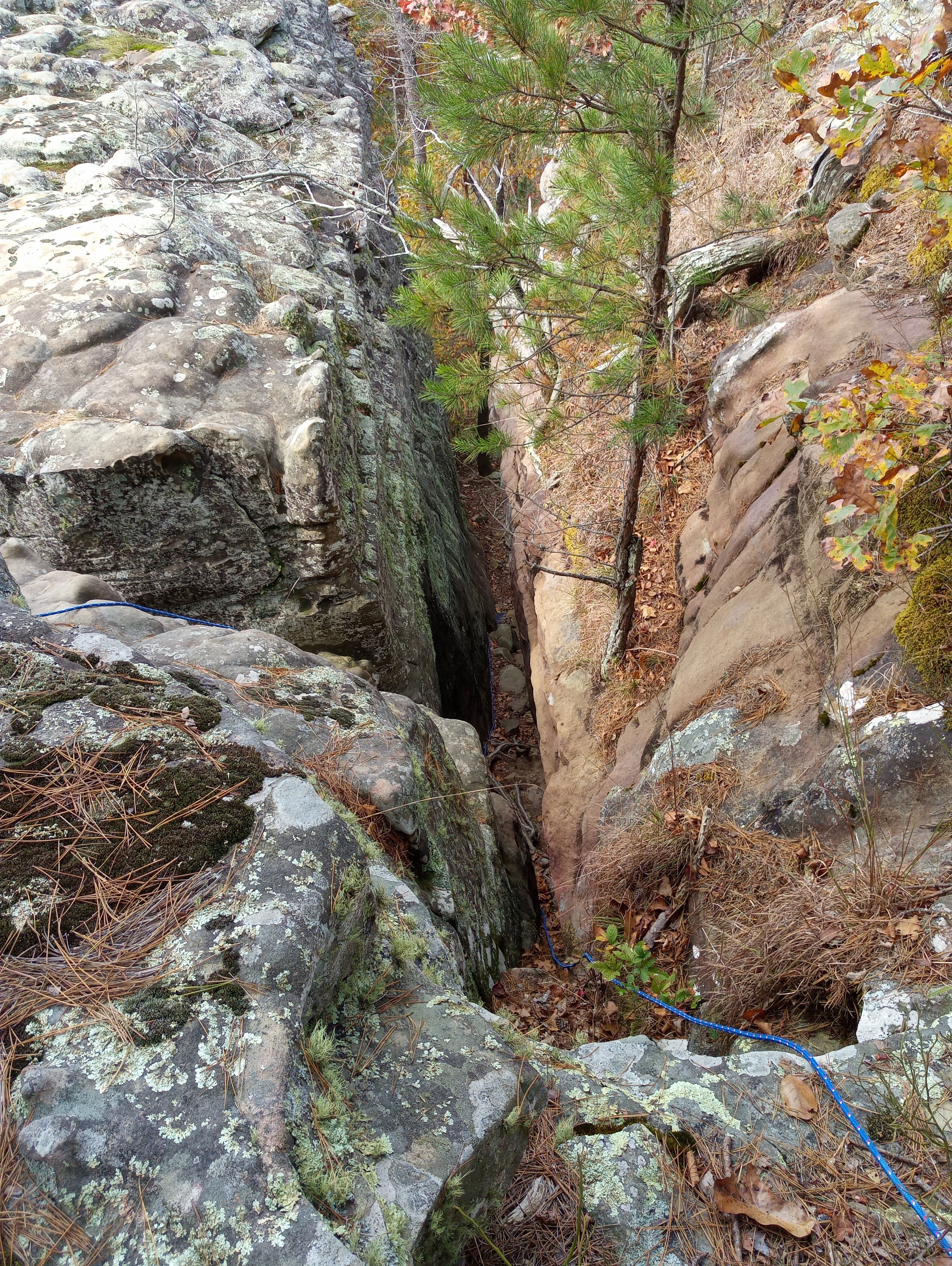
that 'other' bear crack
|
Cave Creek Central Bluffs: Statistics Chart 72 Not hard to find, from Sam's Throne entrance continue south on SR 123 just over 3 miles to FR 92144E (east), from there it's a pretty rough ride a quarter mile to the parking area. Or if coming up from the south to FR 92144E, it's about 6.4 miles north on SR 123 from Lurton at the intersection of SR 123 and SR 7 Spur. |
| base map before fair use alterations is property of ArcGIS--licensed under Creative Commons Attribution-Noncommercial-Share Alike 3.0 U.S. License |


Comments