It has been a year since
our last visit to Big Creek, that’s probably too long for such an awesome place. So far, this spring has seen a lot of rain so we come anticipating beautiful scenery and lots of water.
With our ‘creek waders’ in tow we drive south for Big Creek. Today we’ll start our hike at the ‘old homesite gate’. A metal
gate next to the road and remains of an old home, namely a root cellar and
foundation stones. This is also the main
parking area with room for maybe four cars, try not to block the gate.
 |
Right Fork near crossing
|
We head out on the
old road, past the gate and the homesite then down the hill.
After a good quarter mile, we come
to Right Fork Big Creek, on our right is an old barn and garage which we poke
around a little before crossing the creek.
Last year when we crossed here, we were easily able to skip across on top
of dry rocks. Today though the Right
Fork is swollen and running fast, we don the creek waders hoping for the
best.
 |
ruins of a barn
|
The
creek waders are good for water about eleven inches deep, and this was about their
limit. We head up the bank into a
little hay field. Then another larger
field to the banks of Left Fork Big Creek which has more water than Right
Fork, with rolling white water that we can’t see through to the bottom. Since there is an alternative to crossing
here, we decide to backtrack along the south side
of the field about 150 yards to the route Tim Ernst describes in his book
Arkansas Waterfalls. In a corner on the
south side of this irregular shaped hay field we spot some fluorescent ribbon tied in the trees, this is where the trail
starts.
 |
scenic stop along Left Fork Big Creek
|
Having read of choking greenbrier and blackberry along this off-trail route we are braced for
the worst, at it begins as a nice clean trail, and as it turns out, it is a very clean easy trail with a couple small 'step over' stream crossings and some
ups and downs in between. But with none
of the undergrowth I had read about. A
quarter mile or so from the hay field we notice the trail is getting pretty
close to Left Fork, we stop to admire some scenic large rocks in the
creek. From here another 200 yards brings us to a trail intersection, the right fork heads up and over the hill, I’ll
assume directly to Cave Creek Cascades.
We take the left down to Left Fork and Rock Peninsula Falls.
 |
Rock Peninsula Falls
|
Last year viewed from the north bank, this
time we’re on the south bank so a different perspective. But what we notice right away is the
increased volume of water flowing over the falls, see: (9 Big Creek Cave Falls) for a photo comparison. Rock Peninsula Falls is in its prime today,
with water flowing off all sides it’s just breathtaking. After Rock Peninsula Falls the trail soon
intersects with an old road trace.
 |
many creek views
|
The
road left goes down and crosses Left Fork Big Creek, we turn right and head uphill. About 100 yards farther is Cave Creek
Cascade, a nice long cascade down a steep little creek which flows from the
mouth of a beautiful cave. While Cave
Creek Cascade is nice, the real reason to climb up this tiny drainage is the
cave. The rock face entrance of the small cave is possibly the prettiest rock wall in the entire Big Creek area. |
rugged area along Cove Branch
|
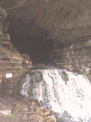
From Cave Creek Cascade
it’s just a short hike around the corner to Big Creek Cave Falls which is the
premier waterfall here. We decide to
skip Big Creek Cave Falls today, which is probably a bad decision, see: (9 Big Creek Cave Falls), for my description and a picture of Big Creek Cave Falls. Just upstream of its confluence with Cave
Creek we cross Cove Branch and continue southeast another 100 feet or so, we then cross Wolf Creek as well.
 |
sinkhole at Underground Falls
|
Are all these creeks getting a little confusing? Maybe I can muddy the waters even more: Cave Creek Cascade, Big Creek Cave Falls, and Wolf Creek Cave Falls all flow from the mouths of caves, and each one a short distance uphill from Cove Branch. That’s right all three flow into Cove Branch,
then downstream a little ways Cove Branch and Wolf Creek join together to form
Left Fork Big Creek. Farther downstream
Right Fork Big Creek flows into Left Fork Big Creek. From there it’s four or five miles
downstream to the community of Vendor, where Left Fork Big Creek flows into Big
Creek, two and a half miles above the Buffalo River.
 |
from below Wolf Creek Falls
|
Now on the east bank of Wolf Creek is the main trail. We follow the road south and soon cross Wolf
Creek, then less than a hundred yards further is Cove Branch. The road crosses here, but we leave the trail and follow upstream along the edge of the narrow bank of Cove Branch on a
volunteer trail. In about 75 yards the trail improves and backs off away
from the ledge and soon arrives at amazing Underground Falls.
This underground waterfall is at the bottom of a small sinkhole. The underground stream enters the sinkhole
then drops twisting downward and disappears.
All very unique and impressive, but watch out, one misstep here could result in a quick drowning and trapped in an underground wet grave…yeah, be careful.
 |
Wolf Creek Cave Falls
|
We stay on the trail heading uphill, and soon see Wolf Creek Cave Falls up
ahead. After passing a gate the trail
levels out at the base of Wolf Creek Cave Falls, another beautiful waterfall
flowing from the mouth of a cave. Wolf
Creek Cave Falls is similar to Big Creek Cave Falls in respect to the layered
shale cave entrances at both falls. But
that’s where similarities end. Wolf
Creek Cave Falls fans out, sort of a steep cascading waterfall. Whereas Big Creek Cave Falls is a straight
drop type falls and taller. Even so,
Wolf Creek Cave Falls is beautiful, with lots
of green moss all over the rocks around the fall. Only 20-30 feet below the falls all the water disappears in the rocks. |
a splash of spring
|
The water reappears briefly in the sinkhole of Underground Falls,
then re-emerges at a spring under a huge boulder in Cove Branch. We head downhill to check this out, soon
arriving on the bank of Cove Branch.
This is another beautiful, tranquil spot on the creek. We sit on a large flat rock. There is more to see upstream including a mineshaft and more waterfalls, but here on the east side of Cove Branch we seem to have come to a dead-end at some thick underbrush. We should really be on the other side of the creek to continue south.
 |
scenic spot on Cove Branch
|
From here we head back north along the ledge above Cove Branch, back to the main trail. But before the crossing over Wolf Creek, we turn right at an intersection with another old road. This trail/old road heads uphill along Wolf
Creek eventually all the way up to Hudson Mountain. However, we soon leave the trail heading east down a volunteer trail to the bank
of Wolf Creek where there is a little waterfall. I’m not sure of the name, I’ve seen it called Wolf Creek Falls, Highchair Falls, and others choose to call it ‘no name falls’ or
‘un-named falls’.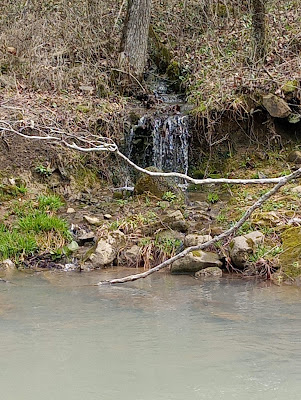 |
a little wet weather fall
|
‘Wolf Creek Falls’ is
alright since it is on Wolf Creek, although that could get confused with Wolf Creek
Cave Falls. I like ‘Highchair Fall’
which is unique and easy to remember, and I’m assuming is named for the big flat rock
wedged against a tree just below the falls.
This rock could be a nice place to view the falls from, although it is a little high. Whatever you call it,
this is a gorgeous little waterfall with a beautiful pool at its base.
 |
Highchair Falls
|
Here at Highchair Falls we decide it’s about time to head back but have a decision to make.
We can either (A) go back the way we came on Tim’s route crossing both
Wolf Creek and Cove Creek, or (B) take the shorter route crossing both Wolf
Creek and then Left Fork at that crossing we ‘by-passed for safety's sake’ earlier. We take (B), hey what the hell, sometimes you got to live a little, we backtrack out to the trail/old road.
 |
spring flowers
|
After crossing Wolf
Creek then another quarter mile to the cattle guard at another
road intersection, we veer to the left which is the old road that follows Left
Fork Big Creek downstream. Another
quarter mile brings us into the first field and 200 yards more to Left
Fork crossing. Maybe the water level has
dropped some since we’ve been here, or maybe the crossing just
isn’t as intimidating from this side of the creek. Whatever the reason it looks good, we don the waders and cross without incident.
On through the big field then the last little field after which we cross Right
Fork. |
rocky Left Fork
|
From here it’s past the barn, up
the hill on the old road and back to the car before you know it. This Big Creek Cave Falls area is always a
great place to hike, and today with the high water it was even more fun. We had a great time, and we’ll be back, after
all there are still waterfalls, caves and an old mineshaft that we
haven’t visited yet. Today’s hike was
just over 5 miles with an elevation gain of 450 feet.
Big Creek Cave Falls: Statistics Chart 43 The small parking area can
fill-up on weekends, is located about 2.8 miles down Coopers Bluff Road (NC 6840) east off Scenic Highway 7 just
over a mile north of the Hwy.7-Hwy.16 intersection (Deer turn-off), or just under a mile south on Highway 7 from the Smith Mountain Road intersection.
 |
base map before fair use alterations is property of ArcGIS-
-licensed under Creative Commons Attribution-Noncommercial-Share Alike 3.0 U.S. License |


Comments