Eleven months ago, while out driving around and exploring Big Piney Creek, we
decided to drive up Parker Ridge Road and found the amazing Parker Ridge full
of bluffs, pedestals and caves. To read about that adventure see: (12 Big Piney Exploration). We
promised that we would return for some hiking, today we make good on that
promise.
 |
Parker Ridge Road
|
The drive from Deer down Parker
Ridge Road takes forever due to a lot of storm damage and the county road crews that are out trying to get the
road back in shape. We finally arrive at
a parking spot at the last hairpin curve before the road descends towards Big Piney Creek, I think this is about halfway down the mountain. |
Parker Ridge Road Falls
|
To start we hike across the road from our parking spot, up a little gully
then uphill some more to the base of Parker Ridge Road Falls. This waterfall is easily over 20 feet tall
but is buried in a crevice, so it will take a lot more water than we have today
to make the falls look good, at least the smooth rounded bluff looks great.
 |
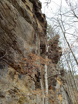
leaning pedestal
|
Technically this hike today is a bushwhack, there are no trails other than 'volunteers' here and there. But this bushwhack is easy, with little if
any undergrowth or elevation change. In fact, the little climb from the road up here to Parker Ridge Road Falls is the
steepest we’ll do all day. Although I
will use the word ‘trail’ in these descriptions today, there
isn’t one, we’re just following the base of the bluffs. From Parker Ridge
Road Falls we follow the bluffline around first south then
east. |
bear cracks are fun
|
Soon are two nice narrow crevices bear
cracks that we explore, most of the bear cracks
we use while hiking are an easy route to either get to the top or the bottom of
a bluff, these two don’t really go anywhere, they’re just fun to check
out. Before the second bear crack the trail
turns to the north, and we see a rock overhang high above. Another tenth of a mile, before
the next turn (to the south) is a big boulder and a shallow cave sort of wedged
in behind it, with a waterfall that is almost dry today.
 |
multi-colored caverns
|
Nearby is a long flat slab of rock facing
south that makes a nice sunny bench for a little break, then 100 feet from the
waterfall is White Rock Cave, this cave is a little bigger and deeper than
the last. About 200 yards past White
Rock Cave is a tall pedestal which is leaning against the bluffline, we pass
through, between pedestal and bluff to the next cave, which is shallow with a
tall entrance, and in another 100 feet
is The Big Room. |
geology 'rocks'
|
The Big Room is big for sure
and the highlight of the hike. It
contains multiple rooms with different entrances, windows, and around the
corner an upstairs room (a little climbing required) also with a window. The Big Room is extremely interesting and a
fun place to explore, we stay a little while enjoying this beauty of a cave. Past the Big Room heading north, we soon
pass beneath a hole in the bluffs above us and 100 feet farther is a nice
shelter style cave up on a little ledge.
 |
tunnel through rock
|
After this shelter the going gets pretty rough with lots of fallen
rock debris and encroaching undergrowth. Another 200 yards we come to
High Noon Falls. This waterfall is a
real gem but could sure use more water today. At the base of High Noon Falls is
a steep gully, which we must cross to continue.
It looks rough, and we decide to call it a day right here, we turn
around and head back the way we came. |
near the Big Room
|
We
will come back no doubt, as there’s more to see along this south facing
bluffline, and there's also the
west facing bluffline and more... Next time I hope to come right after a good
rain since the waterfalls of Parker Ridge seem to dry out quick. We had a good time hiking the bluffline,
exploring caves, crevices and pedestals today, the hike at only 2 miles roundtrip and
less than 50 feet total elevation gain, would have to be rated an easy
bushwhack. |
awesome caves at Parker Ridge
|
After leaving Parker Ridge we drive down to Big Piney Creek and head
north on City Road 311. Having read how
awful this road is, I just want to see if we can even get as far as Rock Creek. The road starts out okay but gets worse in
a hurry. We’re just creeping along of
course when along comes a caravan of ORVs going the other way.
 |
follow the bluffline
|
These are all nice big expensive side-by-sides, many with a back
seat. Like the ones you always see on
trailers with Texas plates. We pull out
at a wide spot to allow them to pass and notice; these are not a bunch of kids,
they’re older like us, and none of
them look happy. We get a lot of dirty
looks as they pass.
 |
High Noon Falls
|
Interesting...anyway
around the tenth or eleventh one stops next to us and the woman in the
passenger seat points at us and says (without malice or contempt) “That’s not a 4-wheeler”, then they drive off. Well, I
never said it was, it’s just our tiny
SUV that we bought a couple years ago right before Christmas. I think maybe her husband was trying to
justify the purchase of his high dollar 'toy' and said to his wife
something like “you need a 4-wheeler to get down roads like this”.
 |
room with a view
|
Well, the road is pretty bad, and it gets worse
the farther we go, we stop just before crossing Rock Creek at a
parking/camping area on the east side of the road. To get across the
creek would require a lot more ground clearance than our tiny SUV has, which
from this day on will always be known as ‘Not a 4-Wheeler’. For more on City Road 311 and Parker Ridge read: (88 A Drive in the Country).
 |
in the dark
|
Parker Ridge: Statistics Chart 42 It's pretty easy to
get here from the small community of Deer.
Parker Ridge Road (NC 7410) heads east off Hwy.16 at Deer Schools, just
look for all the school busses parked next to the school. Follow Parker Ridge Road south and west for
just over 11 miles to parking area 1.
You will know you’re getting close when you start seeing some amazing
rock formations and hairpin curves.
There are other ways to get here including down Pine Ridge Rd. from the
Rosetta/Cow Creek area, or up Big Piney Creek Rd. from Ft. Douglas which
involves fording Hurricane Creek. |
base map before fair use alterations is property of USFS Forest Service-
-licensed under Creative Commons Attribution-Noncommercial-Share Alike 3.0 U.S. License |


Comments