After
my recent hike from Jackson Ridge Trailhead, on top of Ludlow Bluff deep into the Duck Head (see: 198 Silver Mystic), I was studying the map looking for a possible way to hike
down to the base of Ludlow Bluff on the Buffalo at the narrow ‘neck’ of the Duck’s Head (at the beginning of Seven
Mile Bend). Finding a ‘possibility’
named ‘Toney Road’ (MC 6043), today I have decided to check it out. After all, you never know until you go.
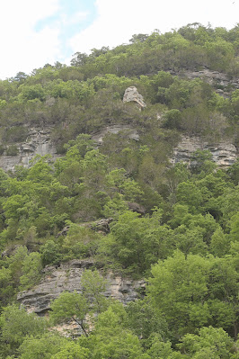 |
a pedestal on Ludlow Bluff
|
The
gravel road is in great shape to my ‘chosen’ starting location, with a cable
gate across what appears to be a driveway.
I park here careful not to block the gate, just north of the gate a man
is loading round bales of hay into the barn.
On my map this gate is right on the boundary of Buffalo Nat. River, so I
ask if it’s okay to park here. He
explains, ‘the park service is in and out all the time and the house is occasionally
rented to college groups, but I should be fine since my truck isn’t blocking
the gate.’ |
| nice ranch-house, property of BNR |
 |
view from top of ridge
|
I
duck under the cable gate and head up the driveway, relieved at my good fortune
of meeting a knowledgeable land-owner to put my mind at ease. At the top of the hill is the good sized ranch
house with stone siding and a few out-buildings. I circle around to the back yard, the place
appears to be well maintained. Where the
mowed lawn ends I see recent tire tracks leaving the yard into the tall grass
following the ridge east. |
| tall grass and a few wildflowers |
 |
below low rocky bluffline
|
Following
the tracks I hope will lead to an old road, but right away I smell
something dead and up ahead a bunch of buzzards spook and take flight as
I approach. Three dead hogs are dumped in the tall grass, naturally with a thick haze of flies
buzzing around. Hastily stepping around
the gruesome scene, I stay in the tire tracks which continue east on the ridge
and soon start gradually heading downhill. |
maybe some caves hidden in there?
|
Not
much further the tracks end near some big old oaks, this is probably where I
cross into the Lower Buffalo Wilderness.
The tall grass is now virgin territory as I bushwhack east. After about 200 more yards of tick infested
tall wet grass with a few wildflowers I finally enter the woods. But no sign of anything resembling a trail this
is all bushwhack all the way, but it’s not bad. |
looking up and downstream on the Buffalo River
|
It isn't steep anyway, and the undergrowth isn’t bad either, we're well into spring now but
these woods are surprisingly clean. The
worst part of this ‘trek’ is the loose rock underfoot, but even this isn’t too
bad. On the south side of this ridge is Toney
Bluff 430 feet tall, but with everything fully leafed-out I rarely catch glimpses
of the river far below. Soon arriving at
the top of a low rocky bluff, I turn to the south looking for a good place to
climb down. |
across sand and gravel is the Buffalo, beyond that Ludlow Bluff
|
After
an easy bluffline break through the rocks I continue east, but now I’m well
below the ridge. I don’t want to climb back up since my goal is the river at
the bottom. I continue mostly
east and downhill but off the ridge the undergrowth is much thicker and a little
confusing as I navigate my way through.
This thick undergrowth continues for about half a mile, then as I get
lower and closer to the river the cane makes its presence, now I’m picking my
way through a jungle without a machete. |
| 590' Ludlow Bluff |
 |
clean sandbar on Buffalo River
|
By
now I’m only about 20 feet above the river, first the rocky ground turned to soft muddy ground, now that has
turned to sand. Soon finding a way down
off the steep river bank I’m out on a long gravel bar near the upstream end of
Bice Bend. Wrapping around Bice Bend I
head downstream on this really clean gravel bar, no flood debris anywhere and
not even a blade of grass growing in the gravel which soon changes to sand as I
head further around the bend. |
short tunnel at river level reminds me of Skull Bluff
|
Across
the Buffalo is 590 foot tall Ludlow Bluff, at 30 feet taller than Big Bluff (see:
187 Centerpoint Trailhead), Ludlow may be the tallest bluff on the
Buffalo. I don’t know about any of that,
but it sure is an awesome sight, for much more on the statistical facts of
bluffs on the Buffalo and lots of historical information explaining the names
of these landmarks get a copy of Ken Smith’s ‘Buffalo River Handbook’ it’s a
great book. |
interesting rock formations where bluff meets river
|
After
almost a third of a mile on this long gravel/sand bar, I spot Slant Rock across
the river on the bank, and just downstream from there a short tunnel through
smooth rock in the river. This reminds
me of Skull Bluff almost 50 miles upriver (see: 100 Skull Bluff). Another 100 feet or so is Buffalo Arch up a
little higher on the bank. Although with
all the ‘jungle’ near river’s edge it’s hard to see much from this side of the
Buffalo. |
float fishing on Buffalo River
|
As
I’m standing here admiring Ludlow Bluff I see four young men in four canoes
coming downstream, they’re all fishing as they float past seemingly oblivious
to the amazing bluff stretching high overhead.
Not much for conversation, I find out they are from Tulsa, another asks
how far to Rush, I reply ‘a little over two miles’ as they float on down the
river. I head to the top of the sand bar
looking for a way up the bank. |
| 'the good life' |
 |
Buffalo Arch?
|
Climbing diagonally up the sandy bank is pretty steep but easy, like climbing a sand-dune, then it’s back in the jungle. The soft ground and cane soon give way to the
rocky woods on the ridge, going back is pretty much all uphill, I make it a point
to stay on the ridge. Nothing too steep,
one steeper section I zig-zag up making good time back to the
low rocky bluffs where I take a break and some pictures. |
| parting shot of the river |
 |
back at low rocky bluff
|
This
bluff encircles the ridge, I explore the rocky cracks and crevices looking for small
caves. Knowing there’s an easy rocky
bluff break back to the south where I came down earlier, I head north instead. I don’t find any caves but soon come to a
nice easy bluffline break, from here on top the low bluff the slope just gets easier as I
go. And it doesn’t take long before I’m
back in the tall grass and sunshine.
Although the grass has dried out, the ticks are still here. |
exploring the rocky bluff
|
When
I reach the mowed back yard behind the house, I do a thorough search for
unwanted hitchhikers, brushing or picking off all the little blood
suckers I can find. I head down the
driveway to my truck outside the gate.
Other than the driveway this hike is a bushwhack all the way, the woods
are relatively ‘clean’ and it’s easy to follow the ridge, so although a trail
is always nice (especially in tick season) it isn’t really a necessity. |
clean woods and cool rocks
|
This
route off Toney Rd. along the top of Toney Bluff, then down to the river beneath
Ludlow Bluff is a great bushwhack adventure. I would suggest doing this hike in
winter when the views open up and the ticks are gone. Today I hiked just under 4 miles with 694
feet of elevation gain. The best part was the sense of satisfaction from finding a good route by just studying
a map, far too often these back roads are either impassable or blocked by
private property. |
tall thistle
|
Toney and Ludlow: Statistics Chart 200 Easy to get here in any car, from
the SR 14/Buffalo River bridge go north about 4.3 miles and turn right (north)
on Rush Road/MC 6035, signed 'Rush Historic District'. Follow
paved Rush Rd. about 1.6 miles to Toney Road/MC 6043, turn right (east) on
this good gravel road. Stay on Toney Rd.
3.0 miles, just past a red (metal siding) barn on the left find the cable gate
and park here but don’t block the gate, plenty of room for one, two would be
tight.
 |
base map before fair use alterations is property of USGS--licensed under Creative Commons Attribution-Noncommercial-Share Alike 3.0 U.S. License
|


Comments