Posts

Showing posts from 2022

136 Search for the Deer Tower Trail

Image
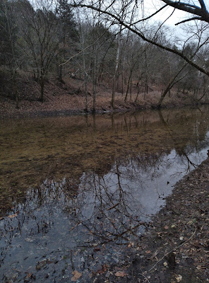
    This morning we head out not really with the intent to go hiking, but on more of a search mission.   On b oth the Forest Service Map and the USGS quad maps a long trail called ‘Deer Tower Trail’ is shown but I haven’t found anything written about this trail.    Also,  we have heard a lot about the fantastic area along Home Valley Bluffs including mysterious Latin inscriptions carved into a large rock, so we're looking for possible parking spots and access to the bluffs.      First, south towards the little town of Deer, now I’m assuming ‘Deer Tower Trail’ is named for the long-gone  Deer fire lookout tower that was located about a mile north of town up on the peak just off Wayton Road.   We turn north on Wayton  Road and  about a mile from Highway 16 on the left is a little campground with three entrances, we pull in to check it out.      I believe this is Deer Tower Campground which is located farther down the hill according to the USGS map.   This might have been a nice littl

135 Clabber Creek to Cedar Creek

Image
     Most folks who do any hiking in the Ozarks, know old roads make good hiking routes, many established trails follow these old roads.   The thing that seems strange to me, why do ‘map makers’ choose not to show old roads in wilderness areas?   The roads didn’t just disappear when the wilderness designation was approved by congress, and since they do make for some great hiking, why remove them from the maps?      Today I’m going hiking with the assumption that an old road exists between Clabber Creek and Cedar Creek along the Buffalo River at the edge of the Lower Buffalo Wilderness, hopefully I’m right, otherwise this will be a long bushwhack. Clabber Creek at Crossing      Down at the bottom of Rush Road past the canoe launch area, I follow the road all the way to its end.   Going through many deep mud holes along the way I park at what is known as ‘Rush parking area 4’ on a leveled hill above the confluence of Clabber Creek at the Buffalo River.   From here in the parking lot,  I

134 Buzzard's Roost SIA

Image
       This morning we have to go into town and pick up some last-minute   items for Thanksgiving dinner, and since it looks like it’s going to be a nice day, we decide to make a day of it by doing a little hiking.  We haven’t seen much rain lately, so we cross off waterfalls from the possibilities list and after a little discussion decide on Buzzard’s Roost way down south.  It is quite a drive,  but we got an early start,  and the scenery is nice, so the drive goes by pretty quick. easy hiking      Buzzard’s Roost is a designated Special Interest Area, but you would never know it from the lack of any signage, without doing a little research we would have never found it.  Just past a little white house we turn left off Maupin Flat Road on an old road which now is an ATV trail, I pull off the road up a low bank and park, with the white house still in site through the trees.  There are a couple more pull off parking spots nearby but not very many, room for maybe five cars max without b

133 Mincy Ridge Road

Image
       This morning we decided to drive the short distance up to the Drury Mincy Conservation Area just across the border in Missouri and hike along one of the many ridgelines.  Later this afternoon a big storm is supposed to move in, so we get an early start.  We drive up the gravel Mincy Road all the way to the end at the locked gate and park at the north side of the road where there is room for 4-5 vehicles.  For more on the Drury Mincy CA see: ( 112 Bear Mountain Loop) and ( 111 Bee Creek and Cornell Rd.) roadside boulders      Past the gate we head south still on the road that I’m going to call ‘Mincy Ridge Road’ since this isn’t a trail but an actual road though it doesn’t appear to be an ‘old road’.  Immediately we pass the tightly spaced rounded boulders I saw on my hike here last winter and  continue south up the hill.  This is easy hiking on the nice wide and clean road, with just some gentle hills to go up and down.  We soon pass another gate, this one open and continue u

132 Bench Trail to Antenna Pine

Image
     Today while not supposed to be hot, won’t be cold either, so a good day to go hiking somewhere.   We decide to try the Bench Trail on the north side of the Ponca Wilderness, mainly because Kat wants a trail with little elevation gain and very little bushwhacking.      Bench Trail is on a bench along the south facing mountain slope, so the trail should be relatively flat , and it is an official trail of the BNR so there shouldn’t be any bushwhacking.   I’ve been curious about the Bench Trail for years and today I’ll finally get to see it for myself. Sherman Mountain through the utility clearing      With two vehicles you could hike the entire Bench Trail pretty easily on a day-hike, going west to east is best with a lot less elevation gain than going the other way.   Today our plan is to check out the east portion of the trail to somewhere around Cecil Hollow then turn around and head back, but if we have some extra energy,   we may climb up into Cecil Hollow to Antenna Pine, w