Last spring after hiking at Tyler Bend, we pulled into Grinders
Ferry just to see what was happening
and noticed the white blazes nailed to trees on both sides of the access
road. Knowing that ‘white’ trail markers
are used for both the Buffalo River Trail and Ozark Highlands Trail, while
‘yellow’ indicates horses allowed, and ‘blue’ blazes are for spur trails. What we didn’t know was that Grinders Ferry
has a trailhead, it isn’t shown on any map I’ve seen, maybe they’re trying to
keep it a secret.
 |
near Illinois Point
|
For more about that ‘discovery’
read: (94 Tyler Bend Loop),
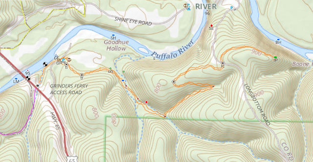
today we’re parking at Grinders Ferry and hiking east on the BRT/OHT. That’s right this is the Buffalo River Trail and the Ozark Highlands Trail, for years at mile marker 164 about where Richland Creek flows into the Buffalo River is where the OHT officially ended, now the OHT is open for continuous hiking from Lake Fort Smith State Park all the way to Dillard’s Ferry on the Buffalo River. |
Hi-Viz trail marker
|
There are no mile
markers as yet on this extended OHT, hopefully they will be coming soon. Also in the planning and construction stages, is a continuation
trail to tie together Dillard’s Ferry to the Spring Creek OHT Trailhead just
south of Almus Knob in the Sylamore district of the Ozark National Forest. A Few short sections of this 'Dillard's to Spring Creek' trail are complete, but a lot of work still remains. |
old homesite
|
Anyway, today we don’t plan to go far since we have no idea what to
expect, meaning a high potential for a sense of discovery, sure I have a topo map on the GPS, but it doesn’t show a trail. Down from the parking area we turn left at
the white blaze which goes sort of south then quickly turning to the east. In no time we come to an intersection with a
blue blaze (spur trail) and through the trees maybe a hundred feet we can see
our parked car. |
high above the Buffalo
|
About 100 yards further the trail enters an old road and to mark the spot a tree is ‘dressed’ in an orange Hi-Viz vest. We’re in the woods right near
the edge of a hay field, just beyond the field is an old
homesite below on our left.
The ruins of the house consist of concrete foundation walls with
concrete steps at both front and back, all this concrete is covered in
green moss. Quite a bit of rusting junk
also litters the area including an old washing machine. |
near the bluff top
|
Just past the homesite the road curves right (southeast) and heads down into Goodhue Hollow. Continuing
south on the road we soon come alongside a small pond wedged between road and creek. Along
the creek the road is mostly
gone, washed away by the creek which we cross twice before coming to an
overhanging bluff across on our left. After crossing the creek a third time the
trail turns up a small side stream to the northeast. The trail follows this little creek uphill for a quarter mile, nothing very steep it’s
just steady uphill to a fourth creek crossing at a sharp turn to
the northwest. Still heading
uphill maybe 300 more yards before leveling out, in a long sweeping
curve north then east we follow the ridge up a little higher to a road. |
at Illinois Point
|
This is Longbottom Road and looks well used, here where trail
crosses road is pretty wide, someone could easily park here at the side
of the road without blocking traffic.
Across the street we continue on the well-marked BRT/OHT slightly up
hill before leveling briefly then heading back downhill. Now on the top of a bluff with
the Buffalo River almost directly below, but in tight against the bluff we can’t
see it. Looking back we see
out onto Lane Bend with old fields, fence lines, a couple ponds and the old
road winding back towards the west. |
old homesite from the trail
|
At a sharp turn back southwest we arrive at Illinois Point, an outlook with beautiful views, to the northwest and Lane Bend, to the northeast is the west side of Gilbert about 300 feet below across the river. At Illinois Point are a couple big rocks to take a break while enjoying the view, which is quite nice, but it could be better once a few
of the big old dead trees right on the point blow over or fall down. The trail onward doesn’t look nearly as well
used as the trail has been so far, and we decide Illinois Point makes
a good turn around point. |
smile you're on candid camera
|
I did say ‘we didn’t plan to go far today’, we head back the way we came.
The return trip is even easier since
going back is mostly downhill. We get back to the car pretty quick and
having had a good time today we plan to check out more of this secret section of the Buffalo
River/Ozark Highlands Trail. Today’s
hike was 3.6 miles with 464 feet of altitude gain.
 |
clean spot in the woods
|
Grinders-Illinois Point: Statistics Chart 104 Grinders Ferry couldn’t be easier to get to. Turn east onto Grinders Ferry Road, which is well signed just 200 yards south of the Highway 65 Buffalo River bridge, then it’s less than a quarter mile to the parking area above the river on the right.
 |
| base map before fair use alterations is property of USGS Topo--licensed under Creative Commons Attribution-Noncommercial-Share Alike 3.0 U.S. License |


Comments