We still have a couple days before the official start of fall, and its
probably too hot today to be out walking around the woods, but I have
been itching to do some hiking. We have chosen the Moore Civilian Conservation
Corp site, as this is a short flat hike
with lots of cool stuff. The Moore CCC
site is just outside the southwest corner of Richland Creek Wilderness above
the banks of Richland Creek. A small parking area is on the left before a locked gate.
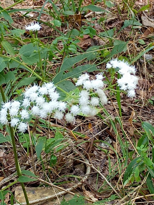 |
White Snakeroot
|
We hike west along the fence
line where we meet a turtle before turning south at the corner where the trail joins an old road. This is easy hiking as there really isn’t any
elevation change other than at the Clark Hollow crossing up ahead, and that isn’t much. The old road follows the fence line, across which is private property to the east.
 |
across the fence (private property)
|
About half a mile farther on this OHT Spur Trail is an intersection (main intersection), to our left is a campsite, we leave the spur turning right on the loop trail around the camp. In less than 100 feet, is a long stone foundation with a concrete floor and
partial basement, this was probably one of the 'barracks' buildings back in the days of Camp Moore.
 |
CCC ruins
|
There are more ‘ruins’ nearby of similar buildings, now mostly just piles of rock. As we
gradually curve back to the south, farther down the trail we come to another
intersection, this is the Ozark
Highlands Trail, a sign at this junction says it’s 9 miles to Fairview
Campground. Now on the OHT we continue south, but not far, it’s only about 50 feet to the next intersection, we turn to the west on a short spur. |
barracks foundation
|
This trail
and most of the others we use today follow old roads that once crisscrossed
the camp back in the days of the Civilian Conservation Corp. We soon come to another campsite, this one
pretty big and quite nice with a big stone pillar. Continuing west there are some nice views
down to Richland Creek. The trail ends at a little shelter above the creek in a small bluff where someone has left their camp chair.
 |
Richland Creek
|
We scramble around and up to the top of the bluff above the shelter with a nice
overlook of Richland Creek, for more on these views and bluffs see: 189 Greenhaw Loop.
Returning the way we came, we’re soon back on the OHT and on our left is
another old structure. This small one-room building has
stone walls, a roof and fireplace, looking around the inside it's dark without windows, an old steel box-spring is leaning against the wall. |
rugged scenery above Richland Creek
|
Past this building is another trail branching off to the south, we take another little side-trip. This trail, also an old road but pretty steep and washed out
leads downhill to Richland Creek in less than 100 yards. At creek level looking upstream is a beautiful large shallow pool stretching all the way to a bend in the stream at the
foot of the bluffs with the small shelter and overlook, looking downstream are cobblestone shoals. |
well-made fireplace
|
Once again, we return the way we came to the OHT and another intersection, this is the OHT junction with the main CCC Trail or ‘OHT Spur Trail’. We turn north here leaving the OHT, for more on the OHT from here headed east see: 178 Ben Hur Trailhead. This soon leads us back
to the main intersection where we turned west earlier, now we turn east here at the
campsite and follow a faint trail 100 feet through the woods to another old building
site.
 |
late summer foliage
|
This site has a nice well-made fireplace and stone chimney, where I make a big
mistake. My socks have slid down into
the toes of my boots and are a little uncomfortable, so I sit down on the
hearth of the fireplace, pull off my boots adjust the socks then lace up my
boots. I’m only sitting here two or
three minutes, but in that short time I’m attacked by a swarm of chiggers. |
a good spot to adjust my socks?
|
Now I’ve had chigger bites before, usually
10-15 bites around my ankles which is bad enough, but this time I’ll end up
with hundreds of bites from head to toe.
Chiggers are so tiny you don’t even know there on you until it’s
too late and that’s the case for me today, I’m oblivious to the tiny demons
eating me alive as we hike the easy half mile or so back to the parking spot. |
Richland Creek
|
Today did get a little warm and muggy but that didn’t really factor in since
this was such a short and easy hike, and it was great to get
back out for some quality time with nature and some interesting history at the
same time. Our hike today is just 2
miles and under 75 feet of elevation gain.
About halfway home I start feeling the chiggers ravaging
my skin and will ‘suffer’ for the better part of a month,
sometimes scratching my skin raw. I was
‘itching’ for some hiking, but not literally!
 |
one room building with fireplace
|
Moore CCC: Statistics Chart 67 Pretty easy to
get to from Ben Hur, which is the 90° turn in SR 16 just 2.7 miles east of Pedestal Rocks Kings Bluff Scenic Area.
Turn left (north) off Hwy.16 on Moore Road (NC 5050) and go about 3.8 miles and turn left (west) just past the concrete bridge over Richland Creek. Follow this narrow dirt road (FR92741A) about
0.1 mile to a parking spot on the left just before a locked gate.
 |
| base map before fair use alterations is property of ArcGIS--licensed under Creative Commons Attribution-Noncommercial-Share Alike 3.0 U.S. License |


Comments